

Size of this preview: 526 × 600 pixels. Other resolutions: 210 × 240 pixels | 421 × 480 pixels | 673 × 768 pixels | 898 × 1,024 pixels | 1,688 × 1,925 pixels.
Original file (1,688 × 1,925 pixels, file size: 2.69 MB, MIME type: image/jpeg)
|
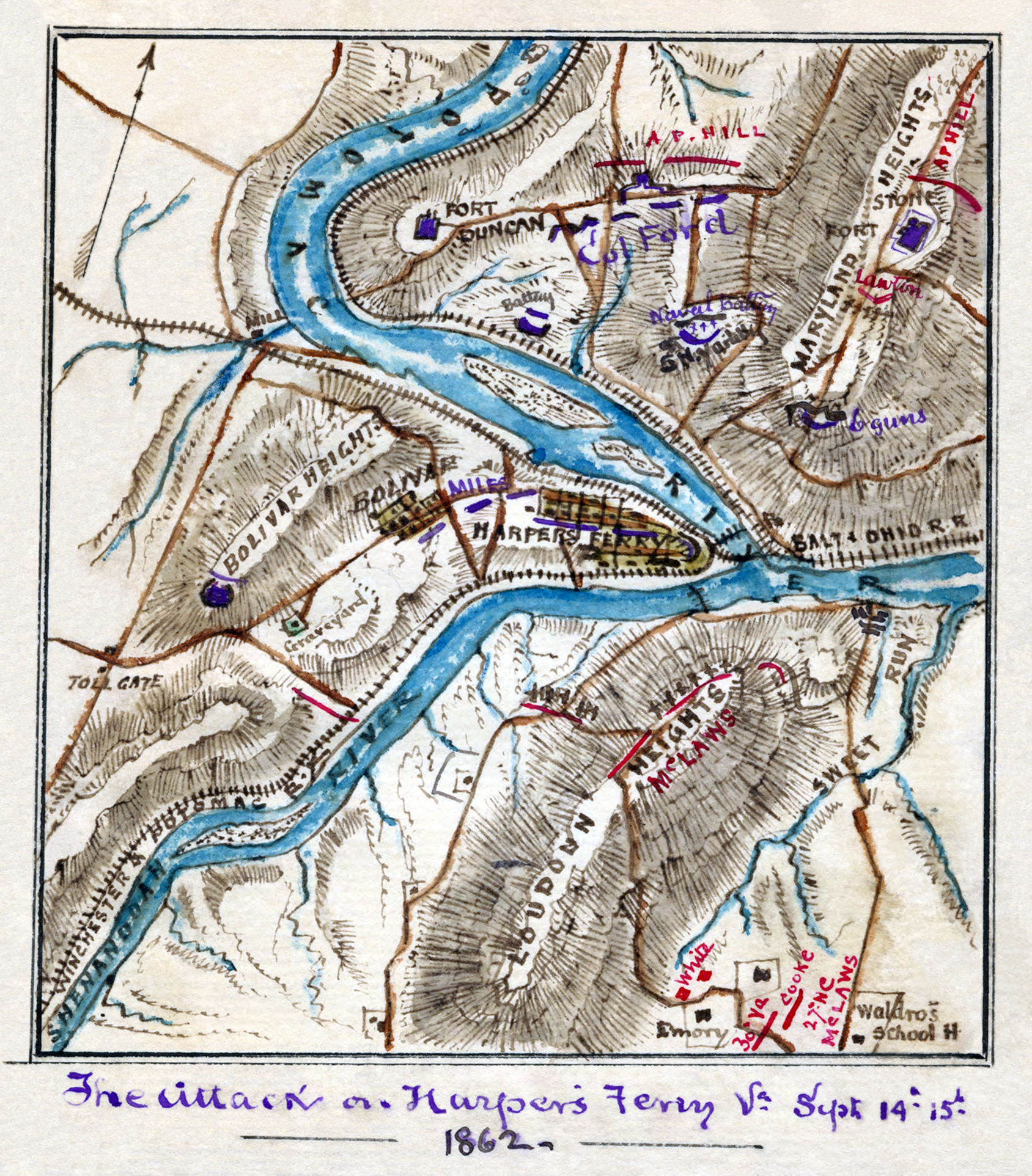
| Description | Scan of a manuscript map by a Union Army mapmaker during the American Civil War. Shows the area surrounding Harper's Ferry, W. Va., at the intersection of the Potomac and Shenandoah Rivers as the Confederate forces under Jackson began their assault, Sept. 12-15, 1862. |
| Date | |
| Source | Library of Congress REPRODUCTION NUMBER Mss5:1 Sn237:1 v. 3 p. 809, In the Robert Knox Sneden Diary (Mss5:1 Sn237:1 v. 3, p. 809). |
| Author | Robert Knox Sneden |
| Other versions | Restored version of Image:attack on Harper's Ferry.jpg. Rotated and cropped, dirt, smudges, and stains removed, levels adjusted, and color balanced. |
| Camera location | | View this and other nearby images on: OpenStreetMap |
|---|
| Open this image as an overlay in Google Earth (Google Maps, Bing) | (Help|Source) |
This media file is in the public domain in the United States. This applies to U.S. works where the copyright has expired, often because its first publication occurred prior to January 1, 1929, and if not then due to lack of notice or renewal. See this page for further explanation.
|
 | |
 |
This image might not be in the public domain outside of the United States; this especially applies in the countries and areas that do not apply the rule of the shorter term for US works, such as Canada, Mainland China (not Hong Kong or Macao), Germany, Mexico, and Switzerland. The creator and year of publication are essential information and must be provided. See Wikipedia:Public domain and Wikipedia:Copyrights for more details.
|
File history
Click on a date/time to view the file as it appeared at that time.
| Date/Time | Thumbnail | Dimensions | User | Comment | |
|---|---|---|---|---|---|
| current | 18:01, 22 July 2008 | | 1,688 × 1,925 (2.69 MB) | Durova | {{Information |Description=Scan of a manuscript map by a Union Army mapmaker during the American Civil War. Shows the area surrounding Harper's Ferry, W. Va., at the intersection of the Potomac and Shenandoah Rivers as the Confederate forces under Jackso |
File usage
The following pages on the English Wikipedia use this file (pages on other projects are not listed):
- Battle of Harpers Ferry
- Robert Knox Sneden
- User:Durova/Featured picture gallery/2008
- User talk:Durova/Archive 61
- User talk:Durova/Archive 65
- Wikipedia:Featured picture candidates/Attack on Harper's Ferrypass5.jpg
- Wikipedia:Featured picture candidates/August-2008
- Wikipedia:Featured pictures/History/American Civil War
- Wikipedia:Featured pictures thumbs/12
- Wikipedia:Picture of the day/February 2009
- Wikipedia:WikiProject Military history/Showcase
- Wikipedia:WikiProject Military history/Showcase/FP
- Wikipedia:WikiProject United States/Featured pictures
- Wikipedia:WikiProject United States/Quality content
- Wikipedia:WikiProject United States/Recognized content
- Wikipedia:Wikipedia Signpost/2008-08-09/Features and admins
- Wikipedia:Wikipedia Signpost/2008-08-09/SPV
- Wikipedia:Wikipedia Signpost/Single/2008-08-09
- Template:POTD/2009-02-15
- Portal:American Civil War
- Portal:American Civil War/Featured picture
- Portal:Maps/Selected picture
- Portal:Maps/Selected picture/47
- Portal:North America/Selected picture
- Portal:North America/Selected picture/45
Global file usage
The following other wikis use this file:
- Usage on de.wikipedia.org
- Usage on fr.wikipedia.org
- Usage on ja.wikipedia.org
- Usage on kn.wikipedia.org
- Usage on ru.wikipedia.org