


Size of this preview: 800 × 587 pixels. Other resolutions: 320 × 235 pixels | 640 × 470 pixels | 1,024 × 752 pixels | 1,280 × 939 pixels | 2,616 × 1,920 pixels.
Original file (2,616 × 1,920 pixels, file size: 456 KB, MIME type: image/jpeg)
Summary
| Description |
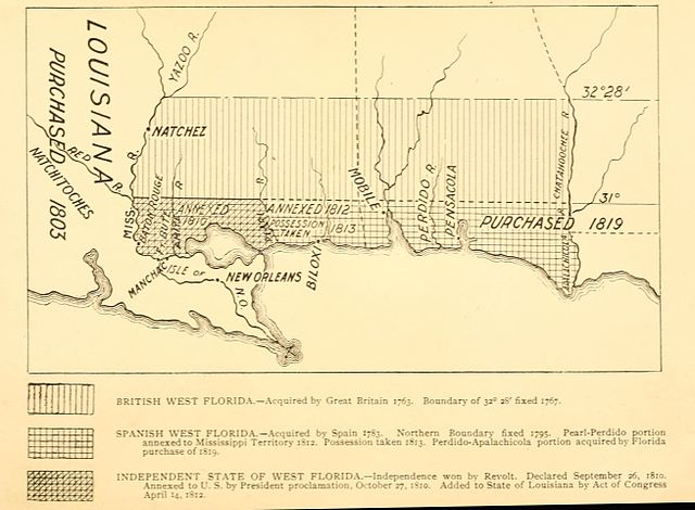
English: A 1903 map showing the territorial changes of "West Florida"; a historical region that now incorporates portions of Louisiana, Mississippi and Alabama |
| Date | |
| Source | West Florida and its relation to the historical cartography of the United States Baltimore, The Johns Hopkins Press 1898 |
| Author | Chambers, Henry E. (Henry Edward), 1860-1929 |
Licensing
This media file is in the public domain in the United States. This applies to U.S. works where the copyright has expired, often because its first publication occurred prior to January 1, 1929, and if not then due to lack of notice or renewal. See this page for further explanation.
|
 | |
 |
This image might not be in the public domain outside of the United States; this especially applies in the countries and areas that do not apply the rule of the shorter term for US works, such as Canada, Mainland China (not Hong Kong or Macao), Germany, Mexico, and Switzerland. The creator and year of publication are essential information and must be provided. See Wikipedia:Public domain and Wikipedia:Copyrights for more details.
|
File history
Click on a date/time to view the file as it appeared at that time.
| Date/Time | Thumbnail | Dimensions | User | Comment | |
|---|---|---|---|---|---|
| current | 20:17, 6 September 2016 | | 2,616 × 1,920 (456 KB) | Jeff in CA | cropped space from the four sides of the image; rotated 1 degree to eliminate tilt |
| 02:58, 8 June 2013 |  | 3,355 × 1,996 (615 KB) | Dudeman5685~commonswiki | User created page with UploadWizard |
File usage
The following pages on the English Wikipedia use this file (pages on other projects are not listed):
Global file usage
The following other wikis use this file:
- Usage on ar.wikipedia.org
- Usage on bn.wikipedia.org
- Usage on es.wikipedia.org
- Usage on gl.wikipedia.org
- Usage on id.wikipedia.org
- Usage on mt.wikipedia.org
- Usage on pt.wikipedia.org
- Usage on ru.wikipedia.org
- Usage on uk.wikipedia.org
- Usage on zh.wikipedia.org