


Size of this PNG preview of this SVG file: 800 × 411 pixels. Other resolutions: 320 × 164 pixels | 640 × 329 pixels | 1,024 × 526 pixels | 1,280 × 657 pixels | 2,560 × 1,314 pixels | 863 × 443 pixels.
Original file (SVG file, nominally 863 × 443 pixels, file size: 1.2 MB)

|
This file may be updated to reflect new information. If you wish to use a specific version of the file without new updates being mirrored, please upload the required version as a separate file. |
Summary
| Description |
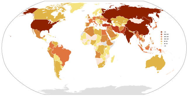
English: Countries by soldier count 中文:世界各國的軍隊人數 日本語: 世界各国の活動中の兵士の規模 |
||||
| Date | |||||
| Source | Own work | ||||
| Author | Danalm000 | ||||
| Other versions |
|


.svg)

.png)


.svg)


.svg)


_Territory_Change_2014-2016.gif)

_(within_Northern_Syria).svg)


.png)
.svg)


_map.png)
.svg)


.svg)


Licensing
I, the copyright holder of this work, hereby publish it under the following license:
This file is licensed under the Creative Commons Attribution-Share Alike 3.0 Unported license.
- You are free:
- to share – to copy, distribute and transmit the work
- to remix – to adapt the work
- Under the following conditions:
- attribution – You must give appropriate credit, provide a link to the license, and indicate if changes were made. You may do so in any reasonable manner, but not in any way that suggests the licensor endorses you or your use.
- share alike – If you remix, transform, or build upon the material, you must distribute your contributions under the same or compatible license as the original.
File history
Click on a date/time to view the file as it appeared at that time.
| Date/Time | Thumbnail | Dimensions | User | Comment | |
|---|---|---|---|---|---|
| current | 14:21, 16 August 2023 | | 863 × 443 (1.2 MB) | Dƶoxar | Reverted to version as of 17:20, 20 November 2020 (UTC) |
| 13:41, 27 July 2022 |  | 512 × 263 (789 KB) | Elementis 54 | Reverted to version as of 08:15, 20 March 2018 (UTC) | |
| 17:20, 20 November 2020 |  | 863 × 443 (1.2 MB) | VladOz | Reverted to version as of 04:57, 25 May 2012 (UTC) Crimea was occupied in 2014, not in 2009, darling | |
| 08:15, 20 March 2018 |  | 512 × 263 (789 KB) | AlexTref871 | In the Crimea, the Russian army. | |
| 04:57, 25 May 2012 |  | 863 × 443 (1.2 MB) | Orionist | corrected Lake Ladoga | |
| 17:13, 28 November 2011 |  | 863 × 443 (1.2 MB) | Danalm000 | One country was accidentally shifted downward.. Corrected.. | |
| 19:38, 21 November 2011 |  | 863 × 443 (1.19 MB) | Danalm000 |
File usage
The following pages on the English Wikipedia use this file (pages on other projects are not listed):
Global file usage
The following other wikis use this file:
- Usage on af.wikipedia.org
- Usage on ar.wikipedia.org
- Usage on as.wikipedia.org
- Usage on be-tarask.wikipedia.org
- Usage on bn.wikipedia.org
- Usage on br.wikipedia.org
- Usage on bs.wikipedia.org
- Usage on ca.wikipedia.org
- Usage on cs.wikipedia.org
- Usage on es.wikipedia.org
- Usage on et.wikipedia.org
- Usage on fa.wikipedia.org
- Usage on fr.wikipedia.org
- Usage on fy.wikipedia.org
- Usage on hi.wikipedia.org
- Usage on hu.wikipedia.org
- Usage on hy.wikipedia.org
- Usage on ja.wikipedia.org
- Usage on ko.wikipedia.org
- Usage on lv.wikipedia.org
- Usage on mn.wikipedia.org
- Usage on pnb.wikipedia.org
- Usage on pt.wikipedia.org
- Usage on ro.wikipedia.org
- Usage on sq.wikipedia.org
- Usage on sr.wikipedia.org
- Usage on ta.wikipedia.org
- Usage on tr.wikipedia.org
- Usage on ur.wikipedia.org
- Usage on zh-min-nan.wikipedia.org
- Usage on zh.wikipedia.org