

The Chaudière River (French for "Cauldron" or "Boiler"; Abenaki: Kik8ntekw[1][2]) is a 185-kilometre-long (115 mi) river with its source near the Town of Lac-Mégantic, in southeast Quebec, Canada. From its source Lake Mégantic in the Estrie region, it runs northwards to flow into the St. Lawrence River opposite Quebec City.
Geography
The river's drainage area is 6,682 square kilometres (2,580 sq mi), initially in the Appalachian Mountains, then in the low-lands of the St. Lawrence, and include 236 lakes covering 62 square kilometres (24 sq mi) and approximately 180,000 inhabitants. Its annual medium flow at the station of Saint-Lambert-de-Lauzon is 114 cubic metres per second (4,000 cu ft/s), varying from 11 cubic metres per second (390 cu ft/s) (low water) to 470 cubic metres per second (17,000 cu ft/s) (spring high water), with historical maximum of 1,760 cubic metres per second (62,000 cu ft/s).
Its principal tributaries are:
- Rivière du Loup (not to be confused with Rivière du Loup in the Bas-Saint-Laurent), also known as the Rivière Linière
- Famine River
- Beaurivage River
- Bras Saint-Victor
The river's basin has nearly 50 percent of the faunal richness of Quebec, namely 330 out of 653 vertebrate species known in the province can be found there.
The river, and the 40-metre-high (130 ft) Chaudière Falls which it passes over, are popular outdoor recreation areas.
Municipalities crossed
Its course crosses the regional county municipalities (MRC) of:
Left bank of the Chaudière river (from the confluence):
- Lévis ("Saint-Rédempteur" and "Saint-Étienne-de-Lauzon" sectors);
- MRC of La Nouvelle-Beauce in Chaudière-Appalaches: municipalities of Saint-Bernard, Saint-Lambert-de-Lauzon, Scott, Sainte-Marie;
- MRC Beauce-Centre in Chaudière-Appalaches: municipalities of Saint-Joseph-des-Érables, Beauceville;
- MRC Beauce-Sartigan, in Chaudière-Appalaches: municipalities of Notre-Dame-des-Pins, Saint-Georges, Saint-Martin, Saint-Gédéon-de-Beauce;
- MRC Le Granit in Estrie: municipalities of Saint-Ludger, Sainte-Cécile-de-Whitton, Lac-Mégantic.
Right bank of the Chaudière river (from the confluence):
- Lévis ("Charny" and "Sainte-Hélène-de-Breakeyville" sectors);
- MRC of La Nouvelle-Beauce in Chaudière-Appalaches: municipalities of Sainte-Marie, Vallée-Jonction,
- MRC Beauce-Centre in Chaudière-Appalaches: municipality of Beauceville,
- MRC of Beauce-Sartigan in Chaudière-Appalaches: municipalities of Saint-Joseph-de-Beauce, Saint-Simon-les-Mines, Saint-Georges, Saint-Martin, Saint-Gédéon-de-Beauce,
- MRC Le Granit in Estrie: municipalities of Saint-Robert-Bellarmin, Frontenac, Audet, Lac-Mégantic ("Fatima" sector)
History
The Abenaki Nation, whose homeland Ndakinna encompasses the river and Chaudière Falls, call it "Kik8ntekw" or "Kikonteku", meaning "River of the Fields." On the charts of Samuel de Champlain, it was given the name "Etchemin River" (a name now used for another river whose drainage area borders with that of the Chaudière River). It was called "Rivière du Sault de la Chaudière" for a period of time before it became simply "Rivière Chaudière" towards the end of the 18th century. This name translates as boiler and refers to the waterfall close to its mouth.
Its location was strategic for French colonization during the 18th century, because the river was a natural link between New France and the British colonies to the south. It was also used by Benedict Arnold at the time of his 1775 expedition in the invasion of Quebec.
In 1823, gold was found along its shores in the Eastern Townships of Quebec.[3]
On 6 July 2013 the Lac-Mégantic derailment caused a major oil spill which contaminated the river at its source at Lac Mégantic.[4] Downstream communities such as Saint-Georges (80 kilometres (50 mi) to the northeast) were forced to obtain potable water from alternate sources and residents asked to limit their water consumption.[5] Floating barriers were installed in an attempt to contain the contamination.
Description
The Chaudière Valley largely crosses the Quebec region of Beauce. It has shaped its industries and its way of life, particularly in spring when its overflows during snowmelt in inhabited areas are frequent, despite its course regulated by 160 dams and retaining dikes. The river runs through several towns and villages in the region, including Saint-Ludger, Saint-Gédéon-de-Beauce, Saint-Martin, Saint-Georges, Notre-Dame-des-Pins, Beauceville, Saint-Joseph-de-Beauce, Vallée-Jonction and Sainte-Marie, Quebec.
The river is a prime site for outdoor activities, particularly near lac Mégantic and Chutes-de-la-Chaudière park. Located near the mouth of the river, in Lévis, this park offers hiking and cycling trails as well as a footbridge suspended over the river, which offers a viewpoint on the fall, 35 metres (115 ft) high. The fall was harnessed for its hydro-electric potential in 1901, but was destroyed in 1970. The dam was rebuilt in 1999 on the remains of the old installations, and supplies a small hydro-electric plant of 24 megawatts (32,000 hp). [6]
Gallery
-
 Lac Mégantic, head lake of the Chaudière.
 -
 The Grand Sault, near Saint-Martin.
 -
 The Sartigan dam at Saint-Georges.
 -
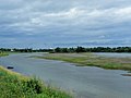
 Meander at Scott, Quebec
 -
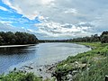
 The islands near Saint-Lambert-de-Lauzon.
 -
 The river in flood.
 -
 The Chaudière Falls.


List of bridges
| Sleepers | Photo | Municipality (ies) | Year of construction | Road | Length | Bridge type |
|---|---|---|---|---|---|---|
| Bridge 16179 | Lake Mégantic | Frontenac Street | Steel girder bridge | |||
| Railway bridge | 
|
Lake Mégantic | Central Maine and Quebec Railway | Steel girder bridge | ||
| Bridge 18952 | Lake Mégantic | Papineau Street | Precast prestressed concrete girder bridge | |||
| Bridge | Lake Mégantic | Québec Central Trail | ||||
| Bridge 10965 | Lake Mégantic | 2005 [7] | 110.6 metres (363 ft)[7] | Steel girder bridge[7] | ||
| Bridge 13899 | Lac-Drolet and Audet | 1969 [8] | Main path | 68.4 metres (224 ft)[8] | Precast prestressed concrete girder bridge[8] | |
| Soucy Bridge | Saint-Ludger | 1958 [9] | Pont Street | 61.5 metres (202 ft)[9] | Reinforced concrete girder bridge[9] | |
| Bridge | Saint-Martin | 2009 | Multifunctional trail | Suspended walkway | ||
| Bridge 13967 | 
|
Saint-Martin | 1970 [10] | 132.1 metres (433 ft)[10] | Steel girder bridge[10] | |
| Sartigan dam | 
|
Saint-Georges | 1967 | Barrage-Sartigan road | Concrete-gravity dam | |
| David-Roy Bridge | 
|
Saint-Georges | 1970 [11] | 184.9 metres (607 ft)[11] | Steel girder bridge[11] | |
| Passerelle de la Seigneurie | 
|
Saint-Georges | Cycle path of the Domaine de la Seigneurie | Steel girder walkway | ||
| Manac footbridge | Saint-Georges | Cycle path of the Domaine de la Seigneurie | Steel girder walkway | |||
| Canam-Boa Franc Gateway | Saint-Georges | Cycle path of the Domaine de la Seigneurie | Steel girder walkway | |||
| Bridge 13921 | Notre-Dame-des-Pins | 1969 [12] | 30th Street | 279.6 metres (917 ft)[12] | Precast prestressed concrete girder bridge[12] | |
| Pont Perrault | 
|
Notre-Dame-des-Pins | 1929 | Cycle lane | 150.9 metres (495 ft) | Covered bridge |
| Desjardins Gateway | 
|
Beauceville | 2008 | Cycle lane | 70 metres (230 ft) | Steel lifting gangway |
| Pont Fortin | 
|
Beauceville | 1980 [13] | 230.9 metres (758 ft)[13] | Steel box girder bridge[13] | |
| Bridge 00793 | Saint-Joseph-de-Beauce and Saint-Joseph-des-Érables | 1908 [14] | 138.6 metres (455 ft)[14] | Lower steel deck bridge[14] | ||
| Bridge 18298 | Vallée-Jonction | Quebec Central Railway | Steel lower deck bridge | |||
| Bridge 00814 | Vallée-Jonction | 1938 [15] | 151.8 metres (498 ft)[15] | Lower steel deck bridge[15] | ||
| Bridge 10861 | Sainte-Marie | 2003 [16] | 164.4 metres (539 ft)[16] | Steel girder bridge[16] | ||
| Family Bridge-Beshro | Sainte-Marie | 2015 [17] | Multifunctional trail | 207 metres (679 ft)[17] | Cable-stayed gangway | |
| Scott's Bridge | Scott | 1995 [18] | 210.1 metres (689 ft)[18] | Steel girder bridge[18] | ||
| Bridge 03994 | Saint-Lambert-de-Lauzon | 1960 [19] | 229.0 metres (751.3 ft)[19] | Steel girder bridge[19] | ||
| Bridge 14760 | Lévis | 1976 [20] | 261.2 metres (857 ft) [20] | Precast prestressed concrete girder bridge[20] | ||
| Bridge 14761 | Lévis | 1975 [21] | 166.6 metres (547 ft)[21] | Precast prestressed concrete girder bridge[21] | ||
| Railway bridge | Lévis | Canadian National | Steel girder bridge | |||
| Chutes-de-la-Chaudière footbridge | 
|
Lévis | Cycle lane | 113 metres (371 ft) | Suspension bridge | |
| Bridge 04011S | Lévis | 1965 [22] | 164.1 metres (538 ft)[22] | Bridge with upper deck in reinforced concrete[22] | ||
| Bridge 04011N | Lévis | 1967 [23] | 164.7 metres (540 ft) [23] | Bridge with upper deck in reinforced concrete[23] | ||
| Bridge 13887 | 
|
Lévis | 1960 [24] | 309.4 metres (1,015 ft) [24] | Steel girder bridge [24] | |
| Railway bridge | Lévis | Canadian National | Steel girder bridge | |||
| Bridge 16928 | Lévis | 2010 [25] | 251.0 metres (823.5 ft)[25] | Steel crutch bridge[25] |
See also
References
- ^ ""field"". Abenaki Dictionary. Retrieved 1 December 2021.
- ^ ""tekw"". Abenaki Dictionary. Retrieved 1 December 2021.
- ^ Law-West, Don. "Gold", in The Canadian Encyclopedia (Edmonton: Hurtig Publishing, 1988), Volume 2, p.908.
- ^ "1 dead after Quebec train blasts". CBC. July 6, 2013. Retrieved July 6, 2013.
- ^ "Leaking oil from Lac-Mégantic disaster affects nearby towns". CBC. July 7, 2013. Retrieved July 7, 2013.
- ^ "Gilles-Lefrançois Facility". innergex.com.
- ^ a b c "Transport infrastructures - Structure details". www.diffusion.transports.gouv.qc.ca (in Canadian French). Retrieved 2017-12-30.
- ^ a b c "Transport infrastructures - Structure details". www.diffusion.transports.gouv.qc.ca (in Canadian French). Retrieved 2017-12-30.
- ^ a b c "Transport infrastructures - Structure details". www.diffusion.transports.gouv.qc.ca (in Canadian French). Retrieved 2017-12-30.
- ^ a b c "Transport infrastructures - Structure details". www.diffusion.transports.gouv.qc.ca (in Canadian French). Retrieved 2017-12-30.
- ^ a b c "Transport infrastructures - Structure details". www.diffusion.transports.gouv.qc.ca (in Canadian French). Retrieved 2017-12-30.
- ^ a b c "Transport infrastructures - Structure details". www.diffusion.transports.gouv.qc.ca (in Canadian French). Retrieved 2017-12-30.
- ^ a b c "Transport infrastructures - Structure details". www.diffusion.transports.gouv.qc.ca (in Canadian French). Retrieved 2017-12-30.
- ^ a b c "Transport infrastructures - Structure details". www.diffusion.transports.gouv.qc.ca (in Canadian French). Retrieved 2017-12-30.
- ^ a b c "Transport infrastructures - Structure details". www.diffusion.transports.gouv.qc.ca (in Canadian French). Retrieved 2017-12-30.
- ^ a b c "Transport infrastructures - Structure details". www.diffusion.transports.gouv.qc.ca (in Canadian French). Retrieved 2017-12-30.
- ^ a b "Inauguration of the Beshro Family Bridge - City of Sainte-Marie". City of Sainte-Marie (in French). 2015-10-08. Retrieved 2017-12-30.
- ^ a b c "Transport infrastructures - Structure details". www.diffusion.transports.gouv.qc.ca (in Canadian French). Retrieved 2017-12-30.
- ^ a b c "Transport infrastructures - Structure details". www.diffusion.transports.gouv.qc.ca (in Canadian French). Retrieved 2017-12-30.
- ^ a b c "Transport infrastructures - Structure details". www.diffusion.transports.gouv.qc.ca (in Canadian French). Retrieved 2017-12-30.
- ^ a b c "Transport infrastructures - Structure details". www.diffusion.transports.gouv.qc.ca (in Canadian French). Retrieved 2017-12-30.
- ^ a b c "Transport infrastructures - Structure details". www.diffusion.transports.gouv.qc.ca (in Canadian French). Retrieved 2017-12-30.
- ^ a b c "Transport infrastructures - Structure details". www.diffusion.transports.gouv.qc.ca (in Canadian French). Retrieved 2017-12-30.
- ^ a b c "Transport infrastructures - Structure details". www.diffusion.transports.gouv.qc.ca (in Canadian French). Retrieved 2017-12-30.
- ^ a b c "Transport infrastructures-Structure details". www.diffusion.transports.gouv.qc.ca (in Canadian French). Retrieved 2017-12-30.