


Size of this PNG preview of this TIF file: 612 × 599 pixels. Other resolutions: 245 × 240 pixels | 490 × 480 pixels | 784 × 768 pixels | 1,045 × 1,024 pixels | 2,441 × 2,391 pixels.
Original file (2,441 × 2,391 pixels, file size: 1.41 MB, MIME type: image/tiff)
Summary
| Description |
English: Map of Congressional Districts in the state of California, reflecting district boundaries current to the 113th United States Congress. |
| Date | |
| Source | National Atlas of the United States (http://nationalatlas.gov/printable/congress.html |
| Author | Department of the Interior |
| Other versions | United States Census Bureau (https://www2.census.gov/geo/maps/cong_dist/uswall/cd116/CD116_US_WallMap.pdf) |
Licensing
This image or file is a work of a United States Census Bureau employee, taken or made as part of that person's official duties. As a work of the U.S. federal government, the image is in the public domain.
|
 |
File history
Click on a date/time to view the file as it appeared at that time.
| Date/Time | Thumbnail | Dimensions | User | Comment | |
|---|---|---|---|---|---|
| current | 06:00, 2 February 2014 | 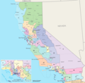 | 2,441 × 2,391 (1.41 MB) | 7partparadigm | User created page with UploadWizard |
File usage
The following pages on the English Wikipedia use this file (pages on other projects are not listed):
Global file usage
The following other wikis use this file:
- Usage on fa.wikipedia.org
- Usage on fr.wikipedia.org
- Usage on ru.wikipedia.org
- Usage on tr.wikipedia.org
- Usage on uk.wikipedia.org
- Usage on zh.wikipedia.org