


Size of this JPG preview of this TIF file: 800 × 570 pixels. Other resolutions: 320 × 228 pixels | 640 × 456 pixels | 1,024 × 730 pixels | 1,280 × 912 pixels | 2,560 × 1,824 pixels | 5,000 × 3,563 pixels.
Original file (5,000 × 3,563 pixels, file size: 16.99 MB, MIME type: image/tiff)
Summary
| FRONT ELEVATION - Daniel Webster House, Hancock Street, Portsmouth, Rockingham County, NH | ||||
|---|---|---|---|---|
| Photographer |
Related names:
|
|||
| Title |
FRONT ELEVATION - Daniel Webster House, Hancock Street, Portsmouth, Rockingham County, NH |
|||
| Depicted place | New Hampshire; Rockingham County; Portsmouth | |||
| Date | Documentation compiled after 1933 | |||
| Dimensions | 5 x 7 in. | |||
| Current location |
Library of Congress Prints and Photographs Division Washington, D.C. 20540 USA http://hdl.loc.gov/loc.pnp/pp.print |
|||
| Accession number |
HABS NH,8-PORT,136-1 |
|||
| Credit line |
|
|||
| Notes |
|
|||
| References |
|
|||
| Source | https://www.loc.gov/pictures/item/nh0116.photos.105871p | |||
| Permission (Reusing this file) |
|
|||

| Object location | | View this and other nearby images on: OpenStreetMap |
|---|
File history
Click on a date/time to view the file as it appeared at that time.
| Date/Time | Thumbnail | Dimensions | User | Comment | |
|---|---|---|---|---|---|
| current | 03:54, 29 July 2014 | 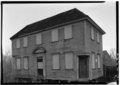 | 5,000 × 3,563 (16.99 MB) | Fæ | GWToolset: Creating mediafile for Fæ. HABS 24 July 2014 (2001:2300) |
File usage
The following pages on the English Wikipedia use this file (pages on other projects are not listed):