


Size of this preview: 424 × 599 pixels. Other resolutions: 170 × 240 pixels | 340 × 480 pixels | 780 × 1,102 pixels.
Original file (780 × 1,102 pixels, file size: 306 KB, MIME type: image/jpeg)

|
This historical map image could be re-created using vector graphics as an SVG file. This has several advantages; see Commons:Media for cleanup for more information. If an SVG form of this image is available, please upload it and afterwards replace this template with
{{vector version available|new image name}}.
It is recommended to name the SVG file “MaineBoundaryDispute.svg”—then the template Vector version available (or Vva) does not need the new image name parameter. |
Summary
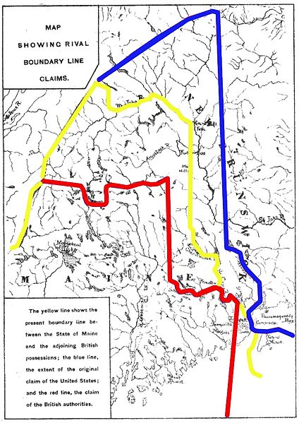
| Description | Map showing competing proposals for the boundary line between the US state of Maine and the British (now Canadian) province of New Brunswick. The red line marks the British proposal, the blue line marks the US proposal, and the yellow line marks the line agreed in the 1842 Webster-Ashburton Treaty, which resolved virtually all of the outstanding boundary issues in this area. |
| Date | Base map published 1888; annotations 2013 |
| Source | Annotations: own work |
| Author | User:Magicpiano |
Licensing
| I, the copyright holder of this work, release this work into the public domain. This applies worldwide. In some countries this may not be legally possible; if so: I grant anyone the right to use this work for any purpose, without any conditions, unless such conditions are required by law. |
File history
Click on a date/time to view the file as it appeared at that time.
| Date/Time | Thumbnail | Dimensions | User | Comment | |
|---|---|---|---|---|---|
| current | 15:18, 15 March 2013 | | 780 × 1,102 (306 KB) | Magicpiano | swap red and blue to match inset text |
| 20:24, 18 February 2013 |  | 780 × 1,102 (306 KB) | Magicpiano | {{Information |Description=Map showing competing proposals for the boundary line between the US state of Maine and the British (now Canadian) province of New Brunswick. The blue line marks the British proposal, the red line marks the US proposal, and ... |
File usage
The following pages on the English Wikipedia use this file (pages on other projects are not listed):
Global file usage
The following other wikis use this file:
- Usage on ar.wikipedia.org
- Usage on ca.wikipedia.org
- Usage on es.wikipedia.org
- Usage on fi.wikipedia.org
- Usage on he.wikipedia.org
- Usage on ja.wikipedia.org
- Usage on pt.wikipedia.org
- Usage on sv.wikipedia.org
- Usage on www.wikidata.org