

Size of this preview: 488 × 599 pixels. Other resolutions: 195 × 240 pixels | 391 × 480 pixels | 625 × 768 pixels | 834 × 1,024 pixels | 1,612 × 1,980 pixels.
Original file (1,612 × 1,980 pixels, file size: 2.37 MB, MIME type: image/jpeg)
Summary
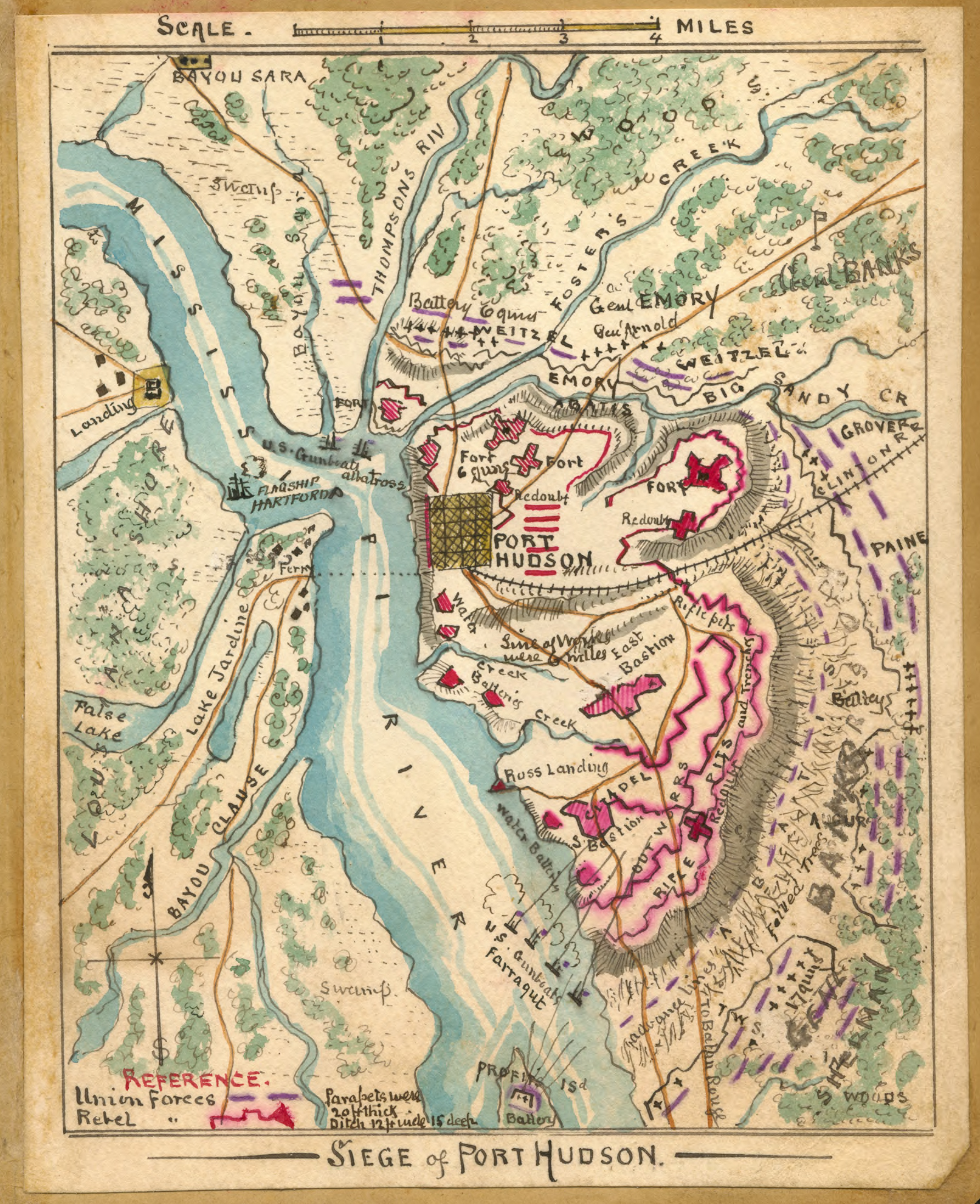
| Description | Map showing the Siege of Port Hudson between May 27th and July 9th, 1863 | |||||||||||||||||||||||
| Date | between 1863 and 1865 | |||||||||||||||||||||||
| Source |
|
|||||||||||||||||||||||
| Author |
|
|||||||||||||||||||||||
| Permission (Reusing this file) |
|
|||||||||||||||||||||||
| Other versions | http://hdl.loc.gov/loc.ndlpcoop/gvhs01.vhs00139 | |||||||||||||||||||||||


Licensing
The author died in 1918, so this work is in the public domain in its country of origin and other countries and areas where the copyright term is the author's life plus 100 years or fewer. | |
| This file has been identified as being free of known restrictions under copyright law, including all related and neighboring rights. | |
File history
Click on a date/time to view the file as it appeared at that time.
| Date/Time | Thumbnail | Dimensions | User | Comment | |
|---|---|---|---|---|---|
| current | 14:14, 16 May 2013 | | 1,612 × 1,980 (2.37 MB) | Magicpiano | Crop border. |
| 02:09, 9 April 2008 |  | 1,769 × 2,170 (2.57 MB) | Kkmurray | {{Information |Description=Map showing the Siege of Port Hudson between May 27th and July 9th, 1863 |Source=US Library of Congress |Date=1863-1865 |Author=Robert Knox Sneden (1832-1918). |Permission=Public Domain (see below) |other_versions= }} Siege o |
File usage
The following pages on the English Wikipedia use this file (pages on other projects are not listed):
Global file usage
The following other wikis use this file:
- Usage on azb.wikipedia.org
- Usage on es.wikipedia.org
- Usage on fr.wikipedia.org
- Usage on it.wikipedia.org
- Usage on ja.wikipedia.org
- Usage on nl.wikipedia.org