

Nobscot Hill is a USGS name[1] for a high point in Middlesex County, Massachusetts with many public hiking trails, and the hill is located in Framingham and Sudbury. At the summit are various radio towers and a fire tower. Below the summit of Nobscot Hill is the Nobscot Scout Reservation (452 acres) which includes Tippling Rock, a popular viewing location. Surrounding the hill are other large parks and parcels of conservation land, including the Nobscot Conservation Land (118 acres), Callahan State Park (958 acres), the Sudbury Weisblatt Conservation Land, and Wittenborg Woods (83 acres),[2] which are connected by various hiking trails, including the Bay Circuit Trail.
Geography
The summit of Nobscot Hill commands a 360-degree view including Boston, MetroWest, the Blue Hills, Lower Kearsarge, Mount Monadnock, Mount Wachusett, Mount Agamenticus, and all of the unremarkable bumps to the SouthWest. Currently, the foliage obscures much of the view from the summit, unless one climbs the fire tower when it is open, but other nearby viewing points, including nearby Jethro's Table and Tippling Rock, offer an unobstructed views to Boston. Other smaller hills surround Nobscot, including Doeskin Hill to the west, which was named in the seventeenth century after someone who lost a deerskin glove on the hill,[3]: 25 and Tantamous Hill to the east, which was named after the medicine man who lived on Nobscot.
History
By 1657 the area appeared in the records by the Nipmuc name "Penobscot" (meaning “Place of the Falling Rock”) and was later shortened to "Nobscot."[4] Nobscot was considered a spiritual place for the Nipmuc people who resided in the area, and there was also a large stone cairn at the summit which possibly served as a lookout area for the Indians. A Nipmuc medicine man named Tantamous, also known as Old Jethro, and his son, Peter Jethro and twelve others, lived on Nobscot Hill prior to King Philip’s War when they were removed in 1675 to Deer Island.[5] The Jethros had fruit orchards and cornfields on the sides of the hill, and many large Indian grinding stones are still viewable. Jethro's Field at Nobscot was referred to in the records by 1649,[6] and references were also made to Peter's Field and Concubine's field in various deeds.[3]: 29 Tippling Rock may have been used to communicate between local Indian villages (the rock was blasted in half in the early 20th century possibly by a local farmer).[7] Jethro also had a granary and cairn (lookout) which was rebuilt in 1927 and was 8 feet in diameter and 5.5 feet tall with a flat smooth stone on top.[8]
In the 1700s Revolutionary War General, John Nixon lived and farmed on the north side of Nobscot Hill and the cellar hole of his house is viewable.[9] During a 1792 outbreak of small pox a pest house was constructed at the base of Nobscot for quarantining the sick and a small burial ground was built for victims who succumbed, and this cemetery and the cellar hole of the pest house may be visited today.
The area around Nobscot was used for farming for many years. Henry David Thoreau visited Nobscot in the 1850s and wrote about viewing the hill and about a waterfall near the hill.[10][11] In the 1920s and 1930s Henry Ford purchased hundreds of acres of land around Nobscot Hill and the Wayside Inn to recreate an authentic early American village, similar to what he eventually built at Greenfield Village in Michigan.[4] Ford constructed a large dam at the base of the hill in the 1930s to create a reservoir to support firefighting near his proposed village, but the dam failed to hold water and is now known as "Ford's Folly," and can be visited by the hiking trails around Nobscot.[4] In 1928 the Boy Scouts purchased a large reservation on Nobscot Hill which is still owned by the organization, but the area is open to the general public as invited guests.[12] In 2008, a 303-acre (1.23 km2) portion of the Nobscot Scout Reservation in Sudbury was permanently conserved by Sudbury Valley Trustees, the Town of Sudbury, and the Mayflower Council, Boy Scouts of America.
-
 Native American corn grinding stone mortar on Legion Trail near Legion Cabin on Nobscot Hill at Nobscot Scout Reservation
 -
 Tippling Rock split open in the early 20th century. Formerly used for communication between Native Americans.
 -
 View from Tippling Rock in Sudbury near Nobscot Hill Reservation, looking toward Boston in the east
 -
 View up the hill toward Tippling Rock in Sudbury Massachusetts near Nobscot Hill Reservation
 -
 "Ford's Folly" dam built by Henry Ford near the base Nobscot Hill and across from the Wayside Inn in Sudbury
 -
 Fire lookout tower at summit of Nobscot
 -
 Nobscot Hill radio antenna
 -
 Smallpox burial ground
 -
 Summit marker embedded in rock with possible remnants of Indian Cairn
 -
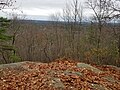 "Jethro's Table" viewing Ledge one minute southeast of Fire Tower on summit of Nobscot


References
- ^ "GNIS Detail - Nobscot Hill". geonames.usgs.gov.
- ^ "Wittenborg Woods | City of Framingham, MA Official Website".
- ^ a b Temple, Josiah Howard, History of Framingham, Massachusetts: Early Known as Danforth's ... (1887) Framingham, Mass.
- ^ a b c "Nobscot Conservation Land » Sudbury".
- ^ "Preserving Nobscot's history - Sudbury, MA - the Sudbury Town Crier". Archived from the original on 9 February 2013.
- ^ Sud. Rcs: Order of 1640: "Jethro's Field"
- ^ "Tippling Rock Hiking".
- ^ "Rebuild Indian Cairn on Nobscot Mountain," The Boston Globe, Sept. 12, 1927, p. 11
- ^ Hudson, Alfred Sereno. (1889). The History of Sudbury, Massachusetts. Town of Sudbury. 661pp.Download PDF
- ^ "Thoreau--Natural History of Massachusetts".
- ^ "The Project Gutenberg eBook of the Writings of Henry David Thoreau, Journal II, 1850-September 15, 1851, by Henry David Thoreau".
- ^ Allan Jung, "Scouting around MetroWest’s Nobscot Reservation," MetroWest Daily News, Oct 23, 2008
| Articles |  | ||||||||||||
|---|---|---|---|---|---|---|---|---|---|---|---|---|---|
| Related Subjects |
| ||||||||||||
| Businesses | |||||||||||||
| People | |||||||||||||
| Neighboring Communities | |||||||||||||