

Size of this preview: 800 × 542 pixels. Other resolutions: 320 × 217 pixels | 640 × 433 pixels | 1,000 × 677 pixels.
Original file (1,000 × 677 pixels, file size: 245 KB, MIME type: image/gif, looped, 38 frames, 1 min 53 s)
Summary
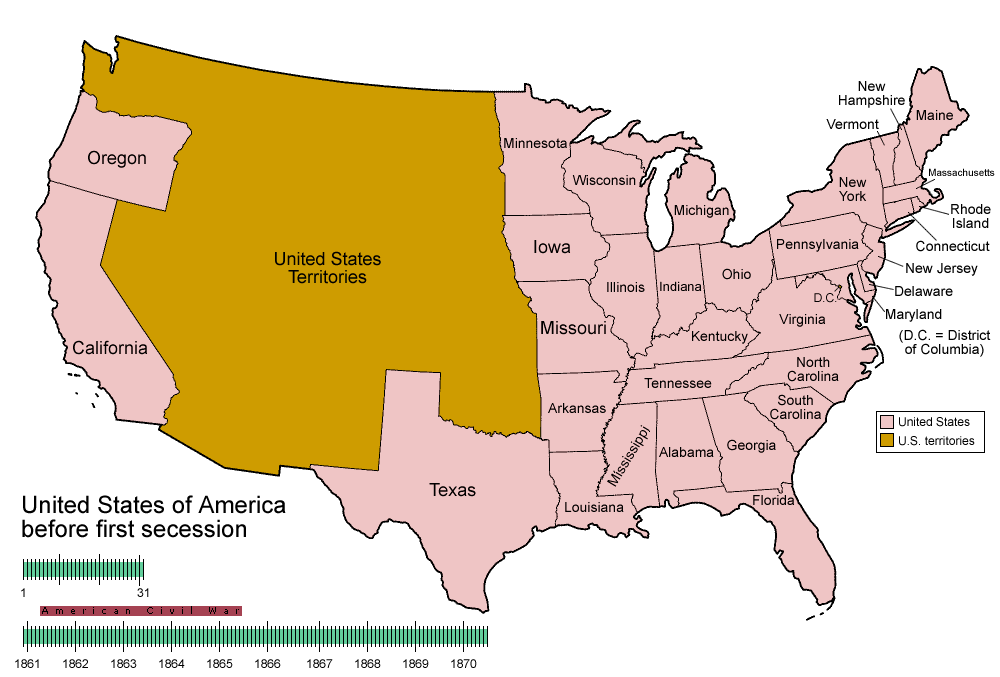
| Description | Animated map/timeline of the territorial evolution of the Confederate States of America, from first secession to end of Reconstruction. |
| Date | |
| Source | Own work |
| Author | User:Golbez |
|
Licensing
I, the copyright holder of this work, hereby publish it under the following licenses:

|
Permission is granted to copy, distribute and/or modify this document under the terms of the GNU Free Documentation License, Version 1.2 or any later version published by the Free Software Foundation; with no Invariant Sections, no Front-Cover Texts, and no Back-Cover Texts. A copy of the license is included in the section entitled GNU Free Documentation License. |
| This file is licensed under the Creative Commons Attribution-Share Alike 3.0 Unported license. | ||
| ||
| This licensing tag was added to this file as part of the GFDL licensing update. |
This file is licensed under the Creative Commons Attribution-Share Alike 2.5 Generic, 2.0 Generic and 1.0 Generic license.
- You are free:
- to share – to copy, distribute and transmit the work
- to remix – to adapt the work
- Under the following conditions:
- attribution – You must give appropriate credit, provide a link to the license, and indicate if changes were made. You may do so in any reasonable manner, but not in any way that suggests the licensor endorses you or your use.
- share alike – If you remix, transform, or build upon the material, you must distribute your contributions under the same or compatible license as the original.
You may select the license of your choice.
File history
Click on a date/time to view the file as it appeared at that time.
| Date/Time | Thumbnail | Dimensions | User | Comment | |
|---|---|---|---|---|---|
| current | 05:30, 5 June 2014 | | 1,000 × 677 (245 KB) | RedXIV | Removed incorrect information. Kentucky and Missouri never seceded. The state governments of Kentucky and Missouri never voted to secede. Claiming that their secession actually happened gives an inaccurate impression of the actual sequence of events. |
| 10:56, 21 December 2013 |  | 1,000 × 677 (256 KB) | ChrisnHouston | I'm the one who broke the thumbnail. I'll try to fix it now... | |
| 13:38, 20 December 2013 |  | 1,000 × 677 (1.75 MB) | Afernand74 | No image displayed. Reupload to try to solve the problem | |
| 11:33, 7 November 2013 |  | 1,000 × 677 (1.75 MB) | ChrisnHouston | Adding a bar to the timeline to indicate when the actual fighting of the Civil War happened, which is one of the most important aspects of this map. | |
| 15:18, 11 April 2012 |  | 1,000 × 677 (254 KB) | Golbez | rv - er, MO and KY were indeed admitted to the CSA, though it lacked any control over them. why not go to the talk page for the CSA on enwp and chat about my next version? | |
| 18:53, 10 April 2012 |  | 1,000 × 677 (225 KB) | Travürsa | Fixed errors. | |
| 01:57, 18 November 2007 |  | 1,000 × 677 (254 KB) | Golbez | Removing frame of WV counties; that was incorrect, they were always part of WV | |
| 09:54, 4 March 2007 |  | 1,000 × 677 (259 KB) | Golbez | == Summary == {{Information |Description=Animated map/timeline of the territorial evolution of the Confederate States of America, from first secession to end of Reconstruction. |Source=Self-made. |Date=March 2007 |Author=User:Golbez |Permission= see b |
File usage
The following pages on the English Wikipedia use this file (pages on other projects are not listed):
- Confederate States of America
- User:TheVirginiaHistorian/sandbox
- User talk:-asx-
- User talk:Golbez/Archive 2
- Wikipedia:Featured picture candidates/CSA states evolution.gif
- Wikipedia:Featured picture candidates/March-2007
- Wikipedia:Featured picture candidates/Non-Native American Nations Control over N America 1750-2008.gif
- Wikipedia:Featured picture candidates/November-2009
- Wikipedia:Featured picture candidates/delist/2010
- Wikipedia:Featured picture candidates/delist/File:CSA states evolution.gif
- Wikipedia:Picture peer review/CSA evolution
- Wikipedia:Village pump (technical)/Archive 110
- Wikipedia:Wikipedia Signpost/2007-03-20/Features and admins
- Wikipedia:Wikipedia Signpost/2007-03-20/SPV
- Wikipedia:Wikipedia Signpost/Single/2007-03-20
- Portal:Maps/Selected picture
- Portal:Maps/Selected picture/11
- Portal:United States/Selected picture
- Portal:United States/Selected picture/15
Global file usage
The following other wikis use this file:
- Usage on af.wikipedia.org
- Usage on bcl.wikipedia.org
- Usage on cs.wikipedia.org
- Usage on da.wikipedia.org
- Usage on de.wikipedia.org
- Usage on eo.wikipedia.org
- Usage on eu.wikipedia.org
- Usage on fr.wikipedia.org
- Usage on fr.wiktionary.org
- Usage on fy.wikipedia.org
- Usage on hr.wikipedia.org
- Usage on hu.wikipedia.org
- Usage on id.wikipedia.org
- Usage on ja.wikipedia.org
- Usage on la.wikipedia.org
- Usage on ms.wikipedia.org
- Usage on pt.wikipedia.org
- Usage on ro.wikipedia.org
- Usage on sr.wikipedia.org
- Usage on th.wikipedia.org
- Usage on tr.wikipedia.org
- Usage on uk.wikipedia.org