


Size of this preview: 448 × 600 pixels. Other resolutions: 179 × 240 pixels | 358 × 480 pixels | 574 × 768 pixels | 765 × 1,024 pixels | 1,936 × 2,592 pixels.
Original file (1,936 × 2,592 pixels, file size: 1.89 MB, MIME type: image/jpeg)
Summary
| Description |
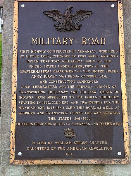
English: Historic marker of US 64/Military Road in Marion, AR near the junction of US 64 and AR 77. |
| Date | |
| Source | Own work |
| Author | DavGreg |
This road is the oldest in Arkansas and was one of the routes for the Trail of Tears.
Licensing
I, the copyright holder of this work, hereby publish it under the following license:
This file is licensed under the Creative Commons Attribution-Share Alike 3.0 Unported license.
- You are free:
- to share – to copy, distribute and transmit the work
- to remix – to adapt the work
- Under the following conditions:
- attribution – You must give appropriate credit, provide a link to the license, and indicate if changes were made. You may do so in any reasonable manner, but not in any way that suggests the licensor endorses you or your use.
- share alike – If you remix, transform, or build upon the material, you must distribute your contributions under the same or compatible license as the original.
File history
Click on a date/time to view the file as it appeared at that time.
| Date/Time | Thumbnail | Dimensions | User | Comment | |
|---|---|---|---|---|---|
| current | 21:23, 27 March 2012 | | 1,936 × 2,592 (1.89 MB) | DavGreg |
File usage
The following pages on the English Wikipedia use this file (pages on other projects are not listed):
Global file usage
The following other wikis use this file:
- Usage on ca.wikipedia.org
- Usage on es.wikipedia.org
- Usage on simple.wikipedia.org
- Usage on zh.wikipedia.org