

Size of this preview: 565 × 599 pixels. Other resolutions: 226 × 240 pixels | 452 × 480 pixels | 1,000 × 1,061 pixels.
Original file (1,000 × 1,061 pixels, file size: 233 KB, MIME type: image/jpeg)
Summary
| Description |
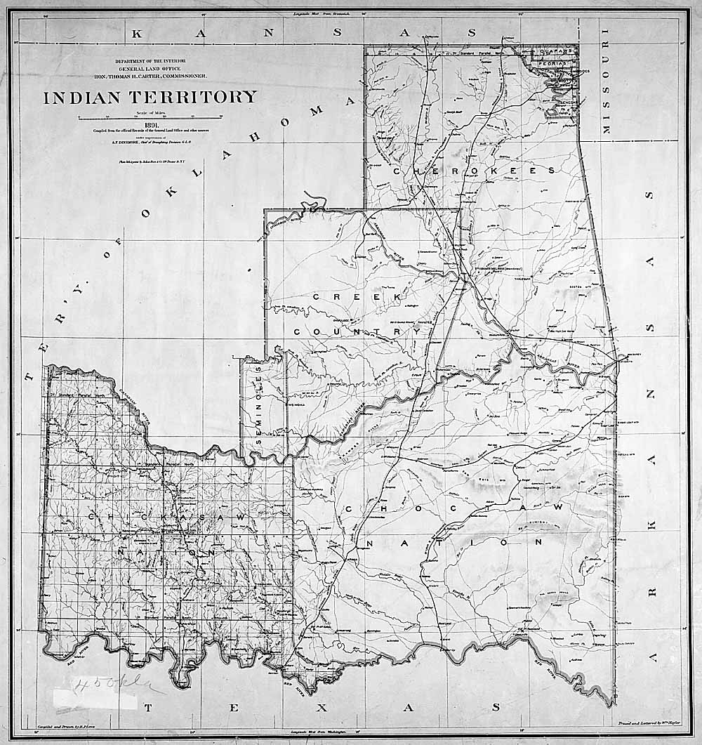
English: Map of Indian territory in Oklahoma in 1891. |
| Date | |
| Source |
National Archives Federal Indian Policy, direct image here. |
| Author | General Land Office, U.S. Department of the Interior |

|
This old map image could be re-created using vector graphics as an SVG file. This has several advantages; see Commons:Media for cleanup for more information. If an SVG form of this image is available, please upload it and afterwards replace this template with
{{vector version available|new image name}}.
It is recommended to name the SVG file “IndianTerritory.svg”—then the template Vector version available (or Vva) does not need the new image name parameter. |
Licensing
| This image or media file contains material based on a work of a United States Department of the Interior employee, created as part of that person's official duties. As a work of the U.S. federal government, such work is in the public domain in the United States. See the Department of the Interior copyright policy for more information. |  |
This media is available in the holdings of the National Archives and Records Administration, cataloged under the National Archives Identifier (NAID) missing.
This tag does not indicate the copyright status of the attached work. A normal copyright tag is still required. See Commons:Licensing.
|
Original upload log
The original description page was here. All following user names refer to en.wikipedia.
- 2004-04-17 03:33 RickK 500×531×8 (79801 bytes) From http://www.archives.gov/digital_classroom/lessons/federal_indian_policy/federal_indian_policy.html, federal government site, public domain
- 2004-04-17 03:32 RickK 500×531×8 (79801 bytes) From http://www.archives.gov/digital_classroom/lessons/federal_indian_policy/federal_indian_policy.html, federal government site, public domain
File history
Click on a date/time to view the file as it appeared at that time.
| Date/Time | Thumbnail | Dimensions | User | Comment | |
|---|---|---|---|---|---|
| current | 16:46, 5 June 2011 | | 1,000 × 1,061 (233 KB) | Clindberg | Larger version from source |
| 16:26, 5 April 2008 |  | 500 × 531 (78 KB) | File Upload Bot (Magnus Manske) | {{BotMoveToCommons|en.wikipedia}} {{Information |Description={{en|From http://www.archives.gov/digital_classroom/lessons/federal_indian_policy/federal_indian_policy.html, federal government site, public domain [[:en:Category:Historical maps of the Unit |
File usage
The following pages on the English Wikipedia use this file (pages on other projects are not listed):
Global file usage
The following other wikis use this file:
- Usage on ca.wikipedia.org
- Usage on de.wikipedia.org
- Usage on es.wikipedia.org
- Usage on it.wikipedia.org
- Usage on kk.wikipedia.org
- Usage on mk.wikipedia.org
- Usage on pl.wikipedia.org
- Usage on pt.wikipedia.org
- Usage on ru.wikipedia.org
- Usage on sr.wikipedia.org
- Usage on uk.wikipedia.org