

High_Water_Mark_-_Cemetery_Ridge,_Gettysburg_Battlefield.jpg (528 × 352 pixels, file size: 45 KB, MIME type: image/jpeg)
Summary
| Description |
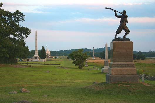
English: "High Water Mark" - Cemetery Ridge, Gettysburg Battlefield
This photo shows the so-called "High Water Mark" as it appears today. This is the location on Cemetery Ridge where the Confederate Army attacked the center of the Union lines on the 3rd day of the Battle of Gettysburg. Although this attack has been popularly known as "Pickett's Charge" it in fact was executed by three Confederate divisions, commanded by Major Generals George Pickett, J. Johnston Pettigrew, and Isaac R. Trimble, consisting of troops from Gen. James Longstreet's First Corps and A.P. Hill's Third Corps. This photo looks south along the Ridge with Little Round Top and Big Round Top in the distant background. The monument in the front is the 72nd Pennsylvania Infantry Monument. |
| Date |
Sculpture:1888, dedicated July 4, 1891.[1] Photo:2005 |
| Source | Originally uploaded as en:Image:3698.jpg on August 27, 2005 by the photographer, then moved at the Commons from Image:3698.jpg to here. Move approved by User:Dgies. |
| Author |
Sculpture: signed Stephens. Photo: Robert Swanson (en:User:Ryssby) |
| Camera location | | View this and other nearby images on: OpenStreetMap |
|---|
Image history at en: (del) (cur) 01:26, 27 August 2005 . . Ryssby . . 564x392 (54055 bytes) (The so-called "high water mark" as it appears today. The is the location where the Confederates made their furtherest thrust north, which in this case was Cemetery Ridge, Gettysburg. )
Licensing
Photo:

|
Permission is granted to copy, distribute and/or modify this document under the terms of the GNU Free Documentation License, Version 1.2 or any later version published by the Free Software Foundation; with no Invariant Sections, no Front-Cover Texts, and no Back-Cover Texts. A copy of the license is included in the section entitled GNU Free Documentation License. |
| This file is licensed under the Creative Commons Attribution-Share Alike 3.0 Unported license. | ||
| ||
| This licensing tag was added to this file as part of the GFDL licensing update. |
Sculpture:
This work is in the public domain in the United States because it was published (or registered with the U.S. Copyright Office) before January 1, 1929.
Public domain works must be out of copyright in both the United States and in the source country of the work in order to be hosted on the Commons. If the work is not a U.S. work, the file must have an additional copyright tag indicating the copyright status in the source country.
Note: This tag should not be used for sound recordings. |
File histhhory
| date/time | username | resolution | size | edit summary |
|---|---|---|---|---|
| 11:39, 2 April 2007 | User:Editor at Large | 528×352 | 45 KB | <span class="comment">(Losslessly cropped border)</span> |
| 15:44, 27 November 2005 | User:Edmund Ferman | 564×392 | 53 KB |
File history
Click on a date/time to view the file as it appeared at that time.
| Date/Time | Thumbnail | Dimensions | User | Comment | |
|---|---|---|---|---|---|
| current | 02:06, 21 April 2008 | | 528 × 352 (45 KB) | BetacommandBot | move approved by: User:Dgies This image was moved from Image:3698.jpg ==Summary== '''Caption read:''' "High Water Mark" - Cemetery Ridge, Gettysburg Battlefield This photo shows the so-called "High Water Mark" as it appears today. This is the |
File usage
Global file usage
The following other wikis use this file:
- Usage on azb.wikipedia.org
- Usage on bg.wikipedia.org
- Usage on ca.wikipedia.org
- Usage on cs.wikipedia.org
- Usage on da.wikipedia.org
- Usage on de.wikipedia.org
- Usage on en.wikiquote.org
- Usage on es.wikipedia.org
- Usage on fr.wikipedia.org
- Usage on he.wikipedia.org
- Usage on it.wikipedia.org
- Usage on ja.wikipedia.org
- Usage on ko.wikipedia.org
- Usage on no.wikipedia.org
- Usage on pl.wikipedia.org
- Usage on pt.wikipedia.org
- Usage on ru.wikipedia.org
- Usage on sr.wikipedia.org
- Usage on sv.wikipedia.org
- Usage on www.wikidata.org
- Usage on zh.wikipedia.org