

Size of this preview: 461 × 600 pixels. Other resolutions: 184 × 240 pixels | 369 × 480 pixels | 590 × 768 pixels | 1,255 × 1,633 pixels.
Original file (1,255 × 1,633 pixels, file size: 551 KB, MIME type: image/png)

|
This ethnographic map image could be re-created using vector graphics as an SVG file. This has several advantages; see Commons:Media for cleanup for more information. If an SVG form of this image is available, please upload it and afterwards replace this template with
{{vector version available|new image name}}.
It is recommended to name the SVG file “Wohngebiet Westlicheabenaki.svg”—then the template Vector version available (or Vva) does not need the new image name parameter. |
Summary
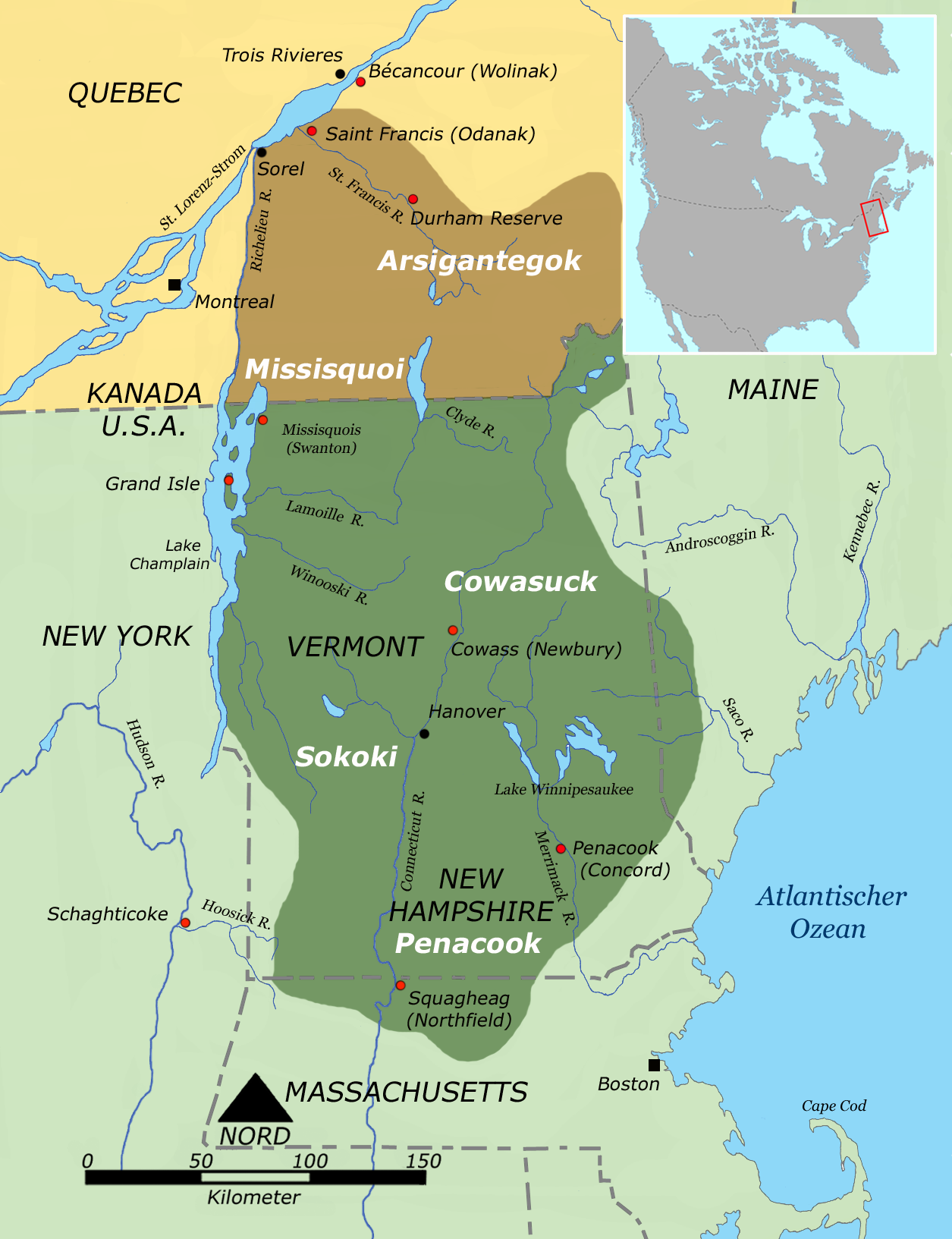
- Description: Tribal territories of Western Abenaki tribes
- Creator: User:Nikater and en:User:ish ishwar (small map)
- Uploader: User:Nikater
- Date: 14 April 2006
- Other Versions: no
- License status: GNU FDL
Bibliography
- Campbell, Lyle. (1997). American Indian languages: The historical linguistics of Native America. New York: Oxford University Press. ISBN 0-19-509427-1.
- Goddard, Ives (Ed.). (1996). Languages. Handbook of North American Indians (W. C. Sturtevant, General Ed.) (Vol. 17). Washington, D. C.: Smithsonian Institution. ISBN 0-1604-8774-9.
- Goddard, Ives. (1999). Native languages and language families of North America (rev. and enlarged ed. with additions and corrections). [Map]. Lincoln, NE: University of Nebraska Press (Smithsonian Institute). (Updated version of the map in Goddard 1996). ISBN 0-8032-9271-6.
- Mithun, Marianne. (1999). The languages of Native North America. Cambridge: Cambridge University Press. ISBN 0-521-23228-7 (hbk); ISBN 0-521-29875-X.
- Sturtevant, William C. (Ed.). (1978-present). Handbook of North American Indians (Vol. 1-20). Washington, D. C.: Smithsonian Institution. (Vols. 1-3, 16, 18-20 not yet published).
Licensing

|
Permission is granted to copy, distribute and/or modify this document under the terms of the GNU Free Documentation License, Version 1.2 or any later version published by the Free Software Foundation; with no Invariant Sections, no Front-Cover Texts, and no Back-Cover Texts. A copy of the license is included in the section entitled GNU Free Documentation License. |
| This file is licensed under the Creative Commons Attribution-Share Alike 3.0 Unported license. | ||
| ||
| This licensing tag was added to this file as part of the GFDL licensing update. |
]] [[Category:
File history
Click on a date/time to view the file as it appeared at that time.
| Date/Time | Thumbnail | Dimensions | User | Comment | |
|---|---|---|---|---|---|
| current | 08:26, 14 April 2006 | | 1,255 × 1,633 (551 KB) | Nikater | |
| 12:51, 13 January 2006 |  | 478 × 946 (795 KB) | Nikater | * Beschreibung: Wohngebiet der Westlichen Abenaki * Quellen: Harenberg Kompaktlexikon, Harenberg Lexikon Verlag und Handbook of North American Indians, Vol. 15, Northeast, Smithsonian Institution, 1978 * Fotograf oder Zeichner: Benutzer:Nikater (neu g |
File usage
The following pages on the English Wikipedia use this file (pages on other projects are not listed):
Global file usage
The following other wikis use this file:
- Usage on ar.wikipedia.org
- Usage on bg.wikipedia.org
- Usage on br.wikipedia.org
- Usage on cs.wikipedia.org
- Usage on de.wikipedia.org
- Usage on es.wikipedia.org
- Usage on fi.wikipedia.org
- Usage on fr.wikipedia.org
- Usage on fr.wiktionary.org
- Usage on gl.wikipedia.org
- Usage on gl.wiktionary.org
- Usage on he.wikipedia.org
- Usage on hr.wikipedia.org
- Usage on it.wikipedia.org
- Usage on ja.wikipedia.org
- Usage on la.wikipedia.org
- Usage on nl.wikipedia.org
- Usage on no.wikipedia.org
- Usage on ru.wikipedia.org
- Usage on sh.wikipedia.org
- Usage on simple.wikipedia.org
- Usage on sr.wikipedia.org
- Usage on sv.wikipedia.org
- Usage on ur.wikipedia.org
View more global usage of this file.