Contents


This is a list of properties and districts in Louisiana that are listed on the National Register of Historic Places. There are listings in each of Louisiana's 64 parishes.
The locations of National Register properties and districts (at least for all showing latitude and longitude coordinates below), may be seen in a map by clicking on "Map of all coordinates".[1]
Current listings by parish


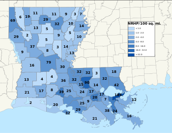
The following are approximate tallies of current listings by parish. These counts are based on entries in the National Register Information Database as of April 24, 2008[2] and new weekly listings posted since then on the National Register of Historic Places web site.[3] There are frequent additions to the listings and occasional delistings and the counts here are approximate and not official. New entries are added to the official Register on a weekly basis.[4] Also, the counts in this table exclude boundary increase and decrease listings which only modify the area covered by an existing property or district, although carrying a separate National Register reference number.
This National Park Service list is complete through NPS recent listings posted April 5, 2024.[5]
See also
- List of National Historic Landmarks in Louisiana
- List of bridges on the National Register of Historic Places in Louisiana
References
- ^ The latitude and longitude information provided in this table was derived originally from the National Register Information System, which has been found to be fairly accurate for about 99% of listings. Some locations in this table may have been corrected to current GPS standards.
- ^ "National Register Information System". National Register of Historic Places. National Park Service. April 24, 2008.
- ^ "National Register of Historic Places: Weekly List Actions". National Park Service. Retrieved January 2, 2009.
- ^ Weekly List Actions, National Register of Historic Places website
- ^ National Park Service, United States Department of the Interior, "National Register of Historic Places: Weekly List Actions", retrieved April 5, 2024.


