

Size of this preview: 432 × 600 pixels. Other resolutions: 173 × 240 pixels | 346 × 480 pixels | 553 × 768 pixels | 737 × 1,024 pixels | 2,401 × 3,334 pixels.
Original file (2,401 × 3,334 pixels, file size: 7.58 MB, MIME type: image/png)
Summary
| Description |
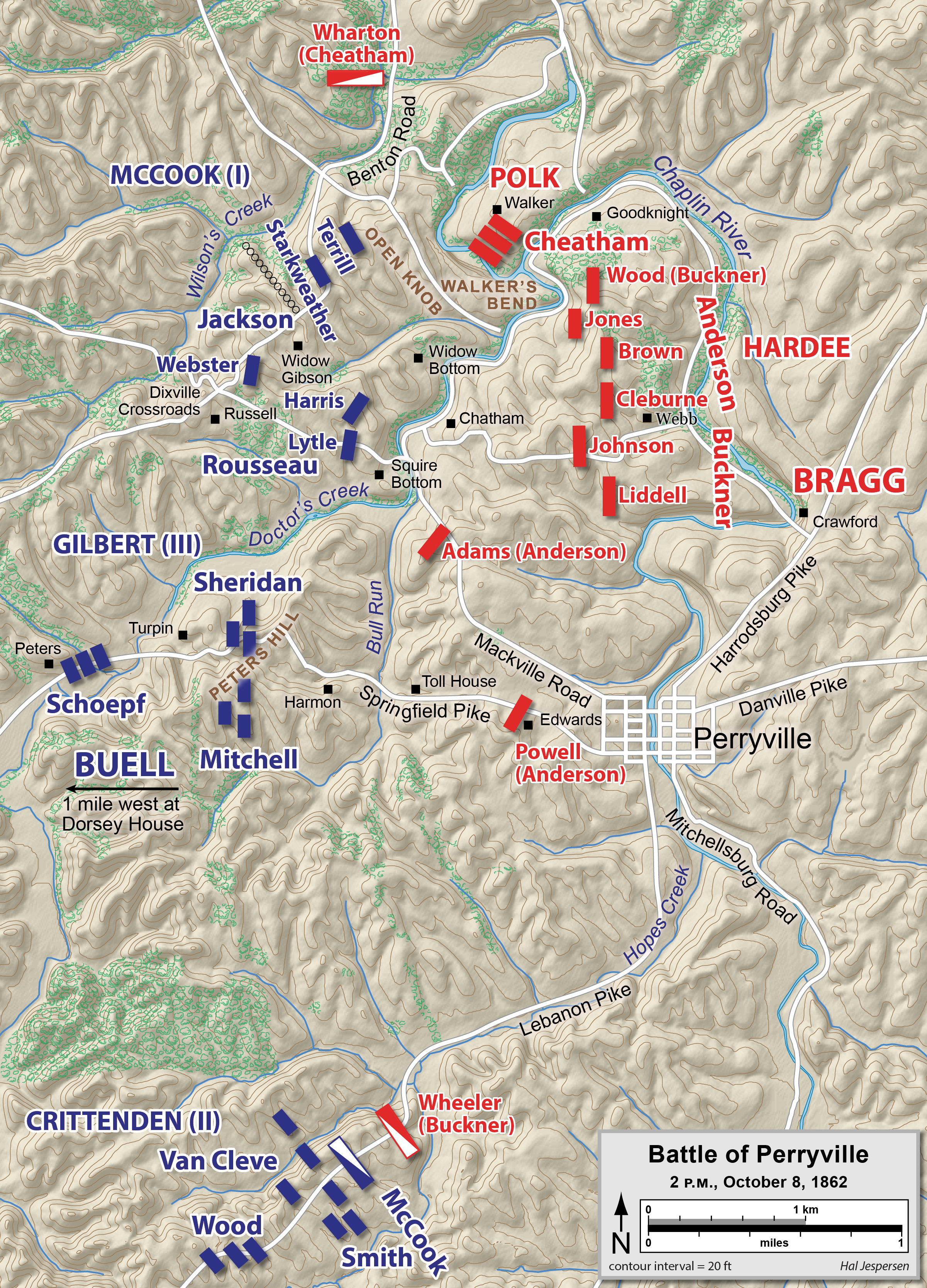
English: Map of the Battle of Perryville of the American Civil War, drawn in Adobe Illustrator CC by Hal Jespersen. Graphic source file is available at http://www.cwmaps.com/ |
| Date | 31 December 2007 (original upload date) |
| Source | Transferred from en.wikipedia to Commons. |
| Author | Hal Jespersen at en.wikipedia |
Licensing
This file is licensed under the Creative Commons Attribution 3.0 Unported license.
Attribution: Map by Hal Jespersen, www.cwmaps.com
- You are free:
- to share – to copy, distribute and transmit the work
- to remix – to adapt the work
- Under the following conditions:
- attribution – You must give appropriate credit, provide a link to the license, and indicate if changes were made. You may do so in any reasonable manner, but not in any way that suggests the licensor endorses you or your use.
Original upload log
The original description page was here. All following user names refer to en.wikipedia.
- 2007-12-31 23:53 Hlj 1500×2313× (1492121 bytes) Map of the [[Battle of Perryville]] of the American Civil War, drawn in Adobe Illustrator CS3 by Hal Jespersen. Graphic source file is available at http://www.posix.com/CWmaps/ [Replaced with lower res version.]
- 2007-12-31 23:39 Hlj 3243×5000× (1905412 bytes) Map of the [[Battle of Perryville]] of the American Civil War, drawn in Adobe Illustrator CS3 by Hal Jespersen. Graphic source file is available at http://www.posix.com/CWmaps/
File history
Click on a date/time to view the file as it appeared at that time.
| Date/Time | Thumbnail | Dimensions | User | Comment | |
|---|---|---|---|---|---|
| current | 20:41, 19 August 2021 | | 2,401 × 3,334 (7.58 MB) | Hlj | Improved topographic background and graphical appearance, corrected some unit state abbreviations. |
| 15:35, 2 April 2015 |  | 6,488 × 10,026 (5.42 MB) | Hlj | Update with some spelling and label overlap fixes, plus some minor graphical improvements. Same license. | |
| 16:35, 26 March 2011 |  | 1,600 × 2,473 (1.64 MB) | Hlj | Update to more recent graphic style, including hills, rivers, and roads. Added legend. {{cc-by-3.0|Map by Hal Jespersen, www.posix.com/CW}} | |
| 16:32, 26 March 2011 |  | 3,244 × 5,013 (2.19 MB) | Hlj | Update to more recent graphic style, including hills, rivers, and roads. Added legend. {{cc-by-3.0|Map by Hal Jespersen, www.posix.com/CW}} | |
| 14:23, 24 January 2010 |  | 1,500 × 2,313 (1.42 MB) | BotMultichill | {{BotMoveToCommons|en.wikipedia|year={{subst:CURRENTYEAR}}|month={{subst:CURRENTMONTHNAME}}|day={{subst:CURRENTDAY}}}} {{Information |Description={{en|Map of the en:Battle of Perryville of the American Civil War, drawn in Adobe Illustrator CS3 by |
File usage
The following pages on the English Wikipedia use this file (pages on other projects are not listed):
Global file usage
The following other wikis use this file:
- Usage on da.wikipedia.org
- Usage on nl.wikipedia.org