

Size of this preview: 400 × 600 pixels. Other resolutions: 160 × 240 pixels | 320 × 480 pixels | 512 × 768 pixels | 682 × 1,024 pixels | 2,500 × 3,750 pixels.
Original file (2,500 × 3,750 pixels, file size: 2.27 MB, MIME type: image/jpeg)
|
Summary
| Description |
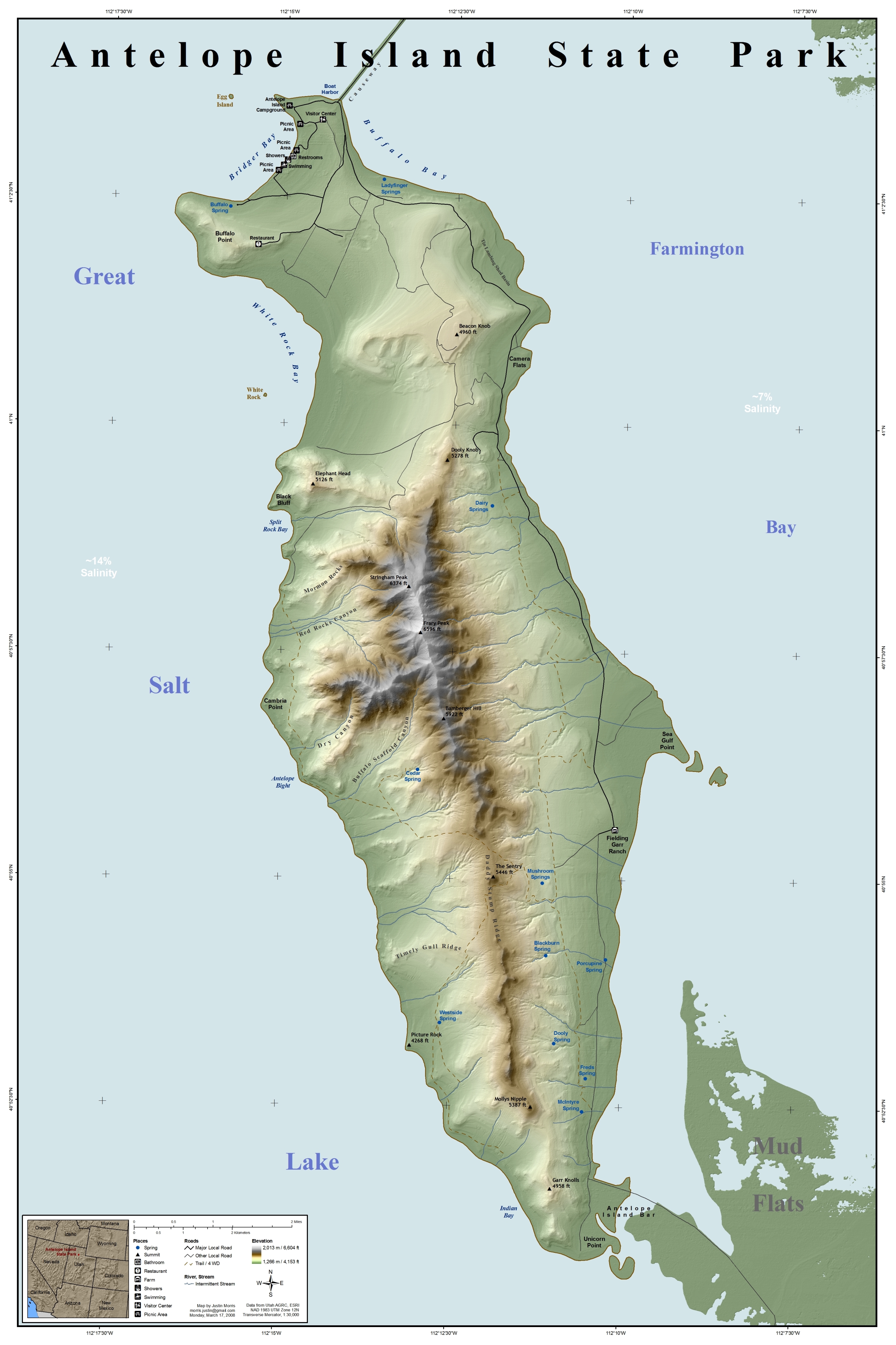
Map of Antelope Island State Park, Utah, Southwestern United States.
|
||
| Date | |||
| Source | This map was entirely self made using ArcGIS. Map data is from Utah AGRC, ESRI and the USGS. | ||
| Author | Justinmorris (talk) | ||
| Permission (Reusing this file) |
I, the copyright holder of this work, hereby publish it under the following license: This file is licensed under the Creative Commons Attribution-Share Alike 3.0 Unported license.
|
||
| Location | Antelope Island |
File history
Click on a date/time to view the file as it appeared at that time.
| Date/Time | Thumbnail | Dimensions | User | Comment | |
|---|---|---|---|---|---|
| current | 14:28, 17 March 2008 | | 2,500 × 3,750 (2.27 MB) | Justinmorris | Removed bathymetric representation. |
| 17:09, 16 March 2008 |  | 2,500 × 3,750 (2.32 MB) | Justinmorris | == Summary == {{Information |Description=Map of Antelope Island State Park, Utah, United States showing predominant features. |Source= {{User:Justinmorris/Source}} |Date=Sunday, March 9, 2008 |Location=Antelope Island |Author=[[User:Justinmorris|J |
File usage
The following pages on the English Wikipedia use this file (pages on other projects are not listed):
- Antelope Island
- Antelope Island bison herd
- Fielding Garr Ranch
- User:Gerry D/50 states
- User:Justinmorris
- User:Justinmorris/Credit
- User:Justinmorris/Maps
- User:Shubinator/Sandbox/Wikipedia Recent additions
- User talk:Justinmorris
- User talk:Justinmorris/Archive01
- Wikipedia:Did you know/Statistics/Monthly DYK pageview leaders/2010
- Wikipedia:Featured picture candidates/Antelope Island State Park Map.jpg
- Wikipedia:Featured picture candidates/April-2008
- Wikipedia:Featured pictures/Diagrams, drawings, and maps/Maps
- Wikipedia:Featured pictures thumbs/11
- Wikipedia:Picture of the day/November 2008
- Wikipedia:Picture peer review/Antelope Island State Park Map
- Wikipedia:Picture peer review/Archives/Jan-Mar 2008
- Wikipedia:Recent additions/2010/February
- Wikipedia:WikiProject United States/Featured pictures
- Wikipedia:WikiProject United States/Quality content
- Wikipedia:WikiProject United States/Recognized content
- Wikipedia:Wikipedia Signpost/2009-01-24/Dispatches
- Wikipedia talk:Wikipedia Signpost/2009-01-24/Dispatches
- Template:POTD/2008-11-02
- Portal:Geography/Featured picture/2009, week 20
- Portal:Geography/Featured picture archive/2009
- Portal:Maps/Selected picture
- Portal:Maps/Selected picture/40
- Portal:National Register of Historic Places/Portal picture
- Portal:National Register of Historic Places/Portal picture/16
- Portal:North America/Selected picture
- Portal:North America/Selected picture/31
- Portal:United States/Did you know/archive/2010/February
Global file usage
The following other wikis use this file:
- Usage on de.wikipedia.org
- Usage on es.wikipedia.org
- Usage on fr.wikipedia.org
- Usage on nl.wikipedia.org
- Usage on no.wikipedia.org
- Usage on pl.wikipedia.org
- Usage on sw.wikipedia.org