

No higher resolution available.
Cahokia_Aerial_HRoe_2015.jpg (450 × 300 pixels, file size: 194 KB, MIME type: image/jpeg)
Summary
| Description |
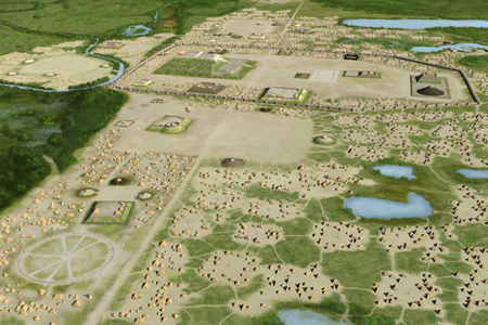
Deutsch: Künstlerische Darstellung von Cahokia in Illinois, der größten Siedlung der Mississippi-Kultur. Sie zeigt den großen, sogenannten Mönchshügel im Zentrum und den Zentralen Platz südlich davon. Der zentrale Bezirk ist von einer Palisade umfasst. Drei weitere Plätze liegen westlich, nördlich und östlich des Mönchshügels. Links unten im Bild ist der Woodhenge-Kreis aus Zedernholzpfählen zu sehen.
English: Artists conception of the Mississippian culture Cahokia Mounds Site in Illinois. The illustration shows the large Monks Mound at the center of the site with the Grand Plaza to its south. This central precinct is encircled by a palisade. Three other plazas surround Monks Mound to the west, north and east. To the west of the western plaza is the Woodhenge circle of cedar posts. |
| Date | |
| Source | Own work |
| Author | Heironymous Rowe |
| Camera location | | View this and other nearby images on: OpenStreetMap |
|---|
Licensing
This file is licensed under the Creative Commons Attribution-Share Alike 4.0 International license.
Attribution: Herb Roe
- You are free:
- to share – to copy, distribute and transmit the work
- to remix – to adapt the work
- Under the following conditions:
- attribution – You must give appropriate credit, provide a link to the license, and indicate if changes were made. You may do so in any reasonable manner, but not in any way that suggests the licensor endorses you or your use.
- share alike – If you remix, transform, or build upon the material, you must distribute your contributions under the same or compatible license as the original.
File history
Click on a date/time to view the file as it appeared at that time.
| Date/Time | Thumbnail | Dimensions | User | Comment | |
|---|---|---|---|---|---|
| current | 22:14, 10 November 2023 | | 450 × 300 (194 KB) | Heironymous Rowe | Reverted to version as of 05:57, 18 January 2018 (UTC) I, the creator of the image, uploaded a specific file and size for free use to wikimedia commons. I did not agree to let users scrape the internet for higher res versions to pirate here |
| 04:59, 30 July 2022 |  | 1,000 × 667 (235 KB) | Artanisen | High quality version of the same artwork - https://spiromounds.com/img/cahokia.jpg | |
| 05:57, 18 January 2018 |  | 450 × 300 (194 KB) | Heironymous Rowe | updated version of illustration | |
| 16:55, 19 October 2016 |  | 450 × 290 (192 KB) | Heironymous Rowe | User created page with UploadWizard |
File usage
The following pages on the English Wikipedia use this file (pages on other projects are not listed):
- Cahokia
- Cahokia Woodhenge
- Cahokia polity
- History of Illinois
- History of Nashville, Tennessee
- List of Mississippian sites
- Mississippian culture
- Mississippian shatter zone
- Mound 34
- Mound Builders
- Native Americans in the United States
- Southern Illinois
- Warren K. Moorehead
- User:Heironymous Rowe/Useful books and their citations
Global file usage
The following other wikis use this file:
- Usage on af.wikipedia.org
- Usage on ast.wikipedia.org
- Usage on ca.wikipedia.org
- Usage on da.wikipedia.org
- Usage on de.wikipedia.org
- Usage on de.wikivoyage.org
- Usage on en.wikivoyage.org
- Usage on eo.wikipedia.org
- Usage on es.wikipedia.org
- Usage on fi.wikipedia.org
- Usage on fr.wikipedia.org
- Usage on he.wikipedia.org
- Usage on hr.wikipedia.org
- Usage on it.wikipedia.org
- Usage on ko.wikipedia.org
- Usage on lt.wikipedia.org
- Usage on ro.wikipedia.org
- Usage on ru.wikipedia.org
- Usage on sl.wikipedia.org
- Usage on sr.wikipedia.org
- Usage on sv.wikipedia.org
- Usage on uk.wikipedia.org
- Usage on uz.wikipedia.org
- Usage on vi.wikipedia.org
- Usage on zh.wikipedia.org