


Size of this preview: 800 × 517 pixels. Other resolutions: 320 × 207 pixels | 640 × 413 pixels | 1,024 × 661 pixels | 1,280 × 827 pixels | 2,058 × 1,329 pixels.
Original file (2,058 × 1,329 pixels, file size: 1.17 MB, MIME type: image/jpeg)
Summary
| Description |
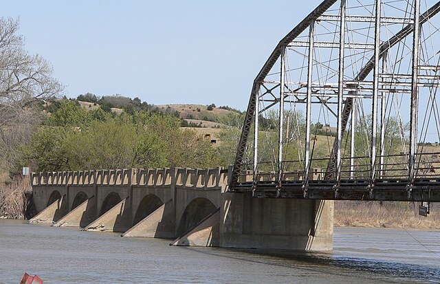
English: North end of Carns State Aid Bridge, crossing the Niobrara River from Rock County, Nebraska on the south bank to Keya Paha County, Nebraska on the north; seen from the southwest. The northern portion of the bridge is a set of five concrete-filled spandrel arch spans; it was built in 1913. A sixth southern span and the approach to the bridge were washed out in 1962; the gap was filled with two truss spans salvaged from elsewhere in the state. The bridge is listed in the National Register of Historic Places. |
| Date | |
| Source | Own work |
| Author | Ammodramus |
| Object location | | View this and other nearby images on: OpenStreetMap |
|---|
Licensing
| I, the copyright holder of this work, release this work into the public domain. This applies worldwide. In some countries this may not be legally possible; if so: I grant anyone the right to use this work for any purpose, without any conditions, unless such conditions are required by law. |
File history
Click on a date/time to view the file as it appeared at that time.
| Date/Time | Thumbnail | Dimensions | User | Comment | |
|---|---|---|---|---|---|
| current | 02:11, 26 April 2010 | | 2,058 × 1,329 (1.17 MB) | Ammodramus | {{Information |Description={{en|1=North end of {{w|Carns State Aid Bridge}}, crossing the {{w|Niobrara River}} from {{w|Brown County, Nebraska}} on the south bank to {{w|Keya Paha County, Nebraska}} on the north; seen from the southwest. The northern por |
File usage
The following pages on the English Wikipedia use this file (pages on other projects are not listed):
Global file usage
The following other wikis use this file:
- Usage on de.wikipedia.org