


Size of this preview: 486 × 600 pixels. Other resolutions: 194 × 240 pixels | 389 × 480 pixels | 987 × 1,218 pixels.
Original file (987 × 1,218 pixels, file size: 46 KB, MIME type: image/png)

|
This locator map image could be re-created using vector graphics as an SVG file. This has several advantages; see Commons:Media for cleanup for more information. If an SVG form of this image is available, please upload it and afterwards replace this template with
{{vector version available|new image name}}.
It is recommended to name the SVG file “Choctaw-Nation.svg”—then the template Vector version available (or Vva) does not need the new image name parameter. |
Summary
| Description |
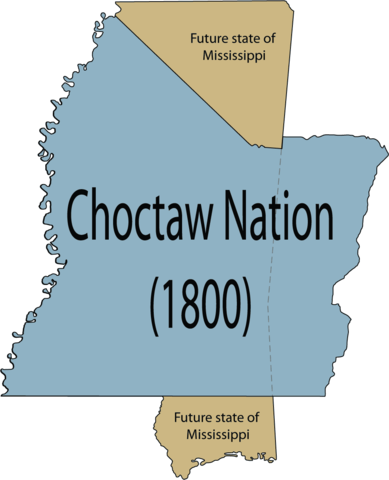
English: Map of the maximum extent of the conquests of the Choctaw tribe in 1800 before land cessions in relation to the U.S. state of Mississippi. |
| Date | |
| Source | Own work |
| Author | Rob (talk) |
Licensing
| This work has been released into the public domain by its author, Robfergusonjr at English Wikipedia. This applies worldwide. In some countries this may not be legally possible; if so: Robfergusonjr grants anyone the right to use this work for any purpose, without any conditions, unless such conditions are required by law. |
Original upload log
The original description page was here. All following user names refer to en.wikipedia.
- 2008-04-23 19:46 Robfergusonjr 987×1218×8 (30444 bytes) {{Information |Description= Map of the complete Choctaw Nation in 1800 before land cessions in relation to the U.S. state of Mississippi. |Source=self-made |Date=April 23, 2008 |Author=~~~ |other_versions= }}
File history
Click on a date/time to view the file as it appeared at that time.
| Date/Time | Thumbnail | Dimensions | User | Comment | |
|---|---|---|---|---|---|
| current | 10:38, 18 January 2012 | | 987 × 1,218 (46 KB) | Sreejithk2000 | Removed white background |
| 23:51, 15 May 2008 |  | 987 × 1,218 (30 KB) | Legoktm | {{BotMoveToCommons|en.wikipedia}} {{Information |Description={{en|Map of the complete Choctaw Nation in 1800 before land cessions in relation to the U.S. state of Mississippi.}} |Source=Transferred from [http://en.wikipedia.org en.wikipedia]<br/> (Origi |
File usage
The following pages on the English Wikipedia use this file (pages on other projects are not listed):
Global file usage
The following other wikis use this file:
- Usage on arz.wikipedia.org
- Usage on bn.wikipedia.org
- Usage on ca.wikipedia.org
- Usage on de.wikipedia.org
- Usage on es.wikipedia.org
- Usage on fr.wikipedia.org
- Usage on ja.wikipedia.org
- Usage on la.wikipedia.org