


Size of this preview: 800 × 532 pixels. Other resolutions: 320 × 213 pixels | 640 × 426 pixels | 1,024 × 681 pixels | 1,280 × 851 pixels | 2,560 × 1,702 pixels | 6,016 × 4,000 pixels.
Original file (6,016 × 4,000 pixels, file size: 6.52 MB, MIME type: image/jpeg)
|
This is an image of a place or building that is listed on the National Register of Historic Places in the United States of America. Its reference number is 98000513. |
| Camera location | | View this and other nearby images on: OpenStreetMap |
|---|
| Description |
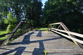
English: Southern end of the abandoned County Line Bridge, which formerly carried County Line Road (Louisa County to the right and Washington County to the left) over Long Creek just west of Columbus Grove, Iowa, United States. The old right-of-way remains on the map, but mosquitos, not humans, are its primary users, while the bridge's wooden floor and railings are unable to hold even the weight of a human. Built in 1893, it is listed on the National Register of Historic Places. |
||
| Date | Taken on 27 July 2015 | ||
| Source | Own work | ||
| Author | Nyttend | ||
| Permission (Reusing this file) |
|
File history
Click on a date/time to view the file as it appeared at that time.
| Date/Time | Thumbnail | Dimensions | User | Comment | |
|---|---|---|---|---|---|
| current | 03:27, 13 August 2015 | | 6,016 × 4,000 (6.52 MB) | Nyttend | {{NRHP|98000513}} {{Location|41|16|1|N|91|29|6.5|W}} {{Information |Description={{en|Southern end of the abandoned {{w|County Line Bridge (Columbus Grove, Iowa)|County Line Bridge}}, which formerly carried County Line Road ({{w|Louisa County, Iowa|Loui... |
File usage
The following pages on the English Wikipedia use this file (pages on other projects are not listed):
Global file usage
The following other wikis use this file:
- Usage on de.wikipedia.org
- Usage on www.wikidata.org