

No higher resolution available.
Jeffriesfordbridge.jpg (375 × 261 pixels, file size: 14 KB, MIME type: image/jpeg)
|
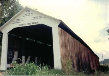
This is an image of a place or building that is listed on the National Register of Historic Places in the United States of America. Its reference number is 78000394. |
| Description | Jeffries Ford Covered Bridge (Some graffiti airbrushed out) | ||
| Date | |||
| Source | Own work | ||
| Author | Jacob Hilt | ||
| Permission (Reusing this file) |
I, the copyright holder of this work, hereby publish it under the following licenses:
This file is licensed under the Creative Commons Attribution-Share Alike 4.0 International, 3.0 Unported, 2.5 Generic, 2.0 Generic and 1.0 Generic license.
You may select the license of your choice. |

| Object location | | View this and other nearby images on: OpenStreetMap |
|---|
File history
Click on a date/time to view the file as it appeared at that time.
| Date/Time | Thumbnail | Dimensions | User | Comment | |
|---|---|---|---|---|---|
| current | 00:11, 17 December 2008 | | 375 × 261 (14 KB) | Parkecountybridges | {{Information |Description= Jeffries Ford Covered Bridge (Some graffiti airbrushed out) |Source= Home Picture |Date= 12/16/08 |Author= Jacob Hilt |Permission= |other_versions= }} |
File usage
The following pages on the English Wikipedia use this file (pages on other projects are not listed):
- Jeffries Ford Covered Bridge
- List of bridges on the National Register of Historic Places in Indiana
- List of covered bridges in Indiana
- List of lost covered bridges in Parke County, Indiana
- National Register of Historic Places listings in Indiana
- National Register of Historic Places listings in Parke County, Indiana
Global file usage
The following other wikis use this file:
- Usage on pt.wikipedia.org
- Usage on www.wikidata.org