


Size of this PNG preview of this SVG file: 776 × 600 pixels. Other resolutions: 311 × 240 pixels | 621 × 480 pixels | 994 × 768 pixels | 1,280 × 989 pixels | 2,560 × 1,978 pixels | 990 × 765 pixels.
Original file (SVG file, nominally 990 × 765 pixels, file size: 12.48 MB)
Summary
| Description |
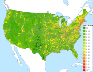
English: Map of United States NRHP/100 sq. mi., by county. Latest update as of March 2019 |
| Date | 01/18/10 |
| Source | Own work |
| Author | 25or6to4 |

|
This file may be updated to reflect new information. If you wish to use a specific version of the file without new updates being mirrored, please upload the required version as a separate file. |
Licensing
I, the copyright holder of this work, hereby publish it under the following licenses:
This file is licensed under the Creative Commons Attribution-Share Alike 3.0 Unported license.
- You are free:
- to share – to copy, distribute and transmit the work
- to remix – to adapt the work
- Under the following conditions:
- attribution – You must give appropriate credit, provide a link to the license, and indicate if changes were made. You may do so in any reasonable manner, but not in any way that suggests the licensor endorses you or your use.
- share alike – If you remix, transform, or build upon the material, you must distribute your contributions under the same or compatible license as the original.

|
Permission is granted to copy, distribute and/or modify this document under the terms of the GNU Free Documentation License, Version 1.2 or any later version published by the Free Software Foundation; with no Invariant Sections, no Front-Cover Texts, and no Back-Cover Texts. A copy of the license is included in the section entitled GNU Free Documentation License. |
You may select the license of your choice.
File history
Click on a date/time to view the file as it appeared at that time.
| Date/Time | Thumbnail | Dimensions | User | Comment | |
|---|---|---|---|---|---|
| current | 13:23, 4 April 2019 | | 990 × 765 (12.48 MB) | Habitator terrae | second try |
| 13:10, 4 April 2019 |  | 990 × 765 (12.48 MB) | Habitator terrae | fix font | |
| 23:59, 10 March 2019 |  | 990 × 765 (12.48 MB) | 25or6to4 | another fix? | |
| 23:46, 10 March 2019 |  | 990 × 765 (12.49 MB) | 25or6to4 | fixes for March 1, 2019 map. | |
| 23:44, 10 March 2019 |  | 990 × 765 (12.84 MB) | 25or6to4 | Updated through March 1, 2019 | |
| 01:38, 29 November 2017 |  | 990 × 765 (12.48 MB) | 25or6to4 | updated thru November 2017 | |
| 07:53, 4 February 2016 |  | 792 × 612 (4.4 MB) | 25or6to4 | graphic and text fixes | |
| 07:39, 4 February 2016 |  | 990 × 765 (12.5 MB) | 25or6to4 | Updated thru 2016/02/01 | |
| 07:45, 8 September 2014 |  | 792 × 612 (4.4 MB) | 25or6to4 | Updated thru September 2014. Now with water! | |
| 15:50, 12 January 2014 |  | 792 × 612 (3.36 MB) | 25or6to4 | Updated through January 2014. |
File usage
The following pages on the English Wikipedia use this file (pages on other projects are not listed):
Global file usage
The following other wikis use this file:
- Usage on de.wikipedia.org
- Usage on fr.wikipedia.org