


Original file (3,008 × 2,000 pixels, file size: 2.95 MB, MIME type: image/jpeg)
|
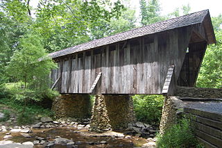
This is an image of a place or building that is listed on the National Register of Historic Places in the United States of America. Its reference number is 72000988. |
| Description |
Located on the West Fork Branch of the Little River, within the Uwharrie National Forest, approximately 14 miles southwest of Asheboro, N.C., survives one of the two remaining covered bridges in the entire state of North Carolina. Most unique of all covered bridges in Randolph County, the Pisgah Bridge has survived the ravages of time and history. The 54’ length Pisgah Covered Bridge was built in 1911 <a href="http://www.co.randolph.nc.us/hlpc/downloads/PisgahCoveredBridgeHistory.pdf" rel="nofollow">www.co.randolph.nc.us/hlpc/downloads/PisgahCoveredBridgeH...</a> |
||
| Date | |||
| Source | Flickr: Pisgah Covered Bridge | ||
| Author | Donald Lee Pardue | ||
| Permission (Reusing this file) |
This file is licensed under the Creative Commons Attribution 2.0 Generic license.
|
| Camera location | | View this and other nearby images on: OpenStreetMap |
|---|
File history
Click on a date/time to view the file as it appeared at that time.
| Date/Time | Thumbnail | Dimensions | User | Comment | |
|---|---|---|---|---|---|
| current | 20:49, 22 December 2012 | | 3,008 × 2,000 (2.95 MB) | Flickr upload bot | Uploaded from http://flickr.com/photo/37216036@N05/7338080156 using Flickr upload bot |
File usage
- List of North Carolina Scenic Byways
- List of bridges on the National Register of Historic Places in North Carolina
- List of covered bridges in North Carolina
- List of covered bridges in the United States
- National Register of Historic Places listings in North Carolina
- National Register of Historic Places listings in Randolph County, North Carolina
- Pisgah Covered Bridge
Global file usage
The following other wikis use this file:
- Usage on pt.wikipedia.org
- Usage on www.wikidata.org