


Size of this preview: 800 × 438 pixels. Other resolutions: 320 × 175 pixels | 640 × 350 pixels | 1,128 × 617 pixels.
Original file (1,128 × 617 pixels, file size: 24 KB, MIME type: image/gif)
Summary
| Description |
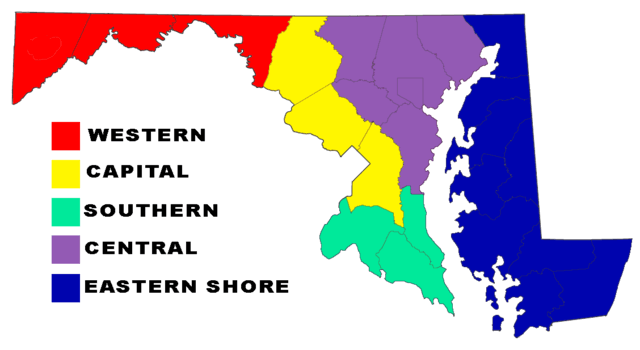
English: colored map of maryland regions |
| Date | 4/7/08 |
| Source | Own work (Original text: self-made) |
| Author | Dgreco (talk) |
Licensing
| This work has been released into the public domain by its author, Dgreco at English Wikipedia. This applies worldwide. In some countries this may not be legally possible; if so: Dgreco grants anyone the right to use this work for any purpose, without any conditions, unless such conditions are required by law. |
Original upload log
Transferred from en.wikipedia to Commons by Autophile using CommonsHelper.
The original description page was here. All following user names refer to en.wikipedia.
- 2008-04-07 22:40 Dgreco 1128×617× (24245 bytes) {{Information |Description=colored map of maryland regions |Source=self-made |Date=4/7/08 |Location= |Author=~~~ |other_versions= }}
File history
Click on a date/time to view the file as it appeared at that time.
| Date/Time | Thumbnail | Dimensions | User | Comment | |
|---|---|---|---|---|---|
| current | 17:17, 5 July 2009 | | 1,128 × 617 (24 KB) | File Upload Bot (Magnus Manske) | {{BotMoveToCommons|en.wikipedia|year={{subst:CURRENTYEAR}}|month={{subst:CURRENTMONTHNAME}}|day={{subst:CURRENTDAY}}}} {{Information |Description={{en|colored map of maryland regions}} |Source=Transferred from [http://en.wikipedia.org en.wikipedia]; tran |
File usage
The following pages on the English Wikipedia use this file (pages on other projects are not listed):
Global file usage
The following other wikis use this file:
- Usage on ar.wikipedia.org
- Usage on bs.wikipedia.org
- Usage on de.wikivoyage.org
- Usage on fr.wikipedia.org
- Usage on hi.wikipedia.org
- Usage on ja.wikipedia.org
- Usage on kn.wikipedia.org
- Usage on la.wikipedia.org
- Usage on pt.wikipedia.org
- Usage on sr.wikipedia.org
- Usage on zh.wikipedia.org