

Size of this preview: 800 × 486 pixels. Other resolutions: 320 × 194 pixels | 640 × 389 pixels | 1,022 × 621 pixels.
Original file (1,022 × 621 pixels, file size: 33 KB, MIME type: image/png)

|
This map has been uploaded by Electionworld from en.wikipedia.org to enable the |
Summary
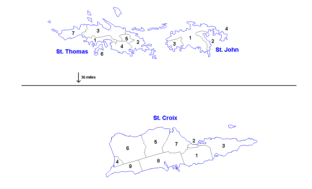
Administrative divisions of the U.S. Virgin Islands. Created by Rarelibra 16:11, 31 March 2006 (UTC) for public domain use. Created using MapInfo Professional v7.5 and vairous mapping resources.
| Districts | Saint Thomas | Saint John | Saint Croix |
|---|---|---|---|
| Sub-districts |
|
|
|
Licensing
| I, the copyright holder of this work, release this work into the public domain. This applies worldwide. In some countries this may not be legally possible; if so: I grant anyone the right to use this work for any purpose, without any conditions, unless such conditions are required by law. |
File history
Click on a date/time to view the file as it appeared at that time.
| Date/Time | Thumbnail | Dimensions | User | Comment | |
|---|---|---|---|---|---|
| current | 13:57, 19 March 2014 | | 1,022 × 621 (33 KB) | Ahnoneemoos | removing border |
| 13:55, 19 March 2014 |  | 1,022 × 621 (33 KB) | Ahnoneemoos | removing border | |
| 20:31, 27 November 2006 |  | 1,025 × 624 (15 KB) | Electionworld | {{ew|en|Rarelibra}} == Summary == Administrative divisions (districts and sub-districts) of the U.S. Virgin Islands. Created by Rarelibra 16:11, 31 March 2006 (UTC) for public domain use. Created using MapInfo Professional v7.5 and |
File usage
The following pages on the English Wikipedia use this file (pages on other projects are not listed):
Global file usage
The following other wikis use this file:
- Usage on ast.wikipedia.org
- Usage on eu.wikipedia.org
- Usage on gl.wikipedia.org
- Usage on li.wikipedia.org
- Usage on mk.wikipedia.org
- Usage on ml.wikipedia.org
- Usage on nn.wikipedia.org
- Usage on no.wikipedia.org
- Usage on os.wikipedia.org
- Usage on sr.wikipedia.org
- Usage on ta.wikipedia.org
- Usage on uk.wikipedia.org
- Usage on vi.wikipedia.org
- Usage on www.wikidata.org