


Size of this preview: 800 × 533 pixels. Other resolutions: 320 × 213 pixels | 640 × 427 pixels | 1,024 × 683 pixels | 1,280 × 853 pixels | 1,800 × 1,200 pixels.
Original file (1,800 × 1,200 pixels, file size: 694 KB, MIME type: image/jpeg)
|
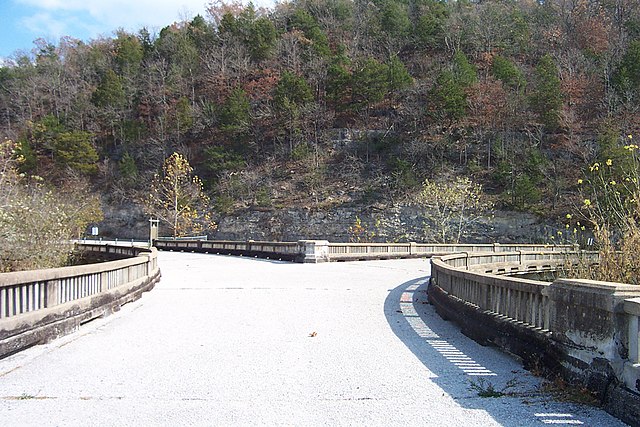
This is an image of a place or building that is listed on the National Register of Historic Places in the United States of America. Its reference number is 91000591. |
| Description |
English: The Y-Bridge looking east. Former Route 43 continued right, former Route 44 continued left. Galena, Missouri, USA. |
||||||||
| Date | (according to image EXIF data) | ||||||||
| Source |
Own work (Rt66lt) English: Transferred from en.wikipedia.org [1]: 2006-05-11T20:04:17 . . Rt66lt . . 1800×1200 694 KB . . Self-taken photo) |
||||||||
| Author | Rt66lt | ||||||||
| Permission (Reusing this file) |
Rt66lt, the copyright holder of this work, hereby publishes it under the following license:
|

![[1]](https://en.wikipedia.org/wiki/Image:Y-Bridge_1.JPG)
| Object location | | View this and other nearby images on: OpenStreetMap |
|---|
File history
Click on a date/time to view the file as it appeared at that time.
| Date/Time | Thumbnail | Dimensions | User | Comment | |
|---|---|---|---|---|---|
| current | 05:00, 7 September 2007 | | 1,800 × 1,200 (694 KB) | Scott5114 | {{Information |Description=The w:Y-Bridge (Galena, Missouri) in Galena, Missouri, USA. |Source=[http://en.wikipedia.org/wiki/Image:Y-Bridge_1.JPG English Wikipedia] |Date=2002-09-13 (according to image EXIF data) |Author=w:User:Rt66lt |othe |
File usage
The following pages on the English Wikipedia use this file (pages on other projects are not listed):
Global file usage
The following other wikis use this file:
- Usage on de.wikipedia.org
- Usage on uz.wikipedia.org
- Usage on www.wikidata.org