[3] Name on the Register[4]
Image
Date listed[5]
Location
City or town
Description
1
Blair Farm Blair Farm August 29, 2008 (#08000812 ) N. side of NC 1522 just W. of its jct. with Blairmont Dr. 36°12′11″N 81°38′52″W / 36.203056°N 81.647778°W / 36.203056; -81.647778 (Blair Farm ) Boone
2
Blue Ridge Tourist Court Upload image April 18, 2023 (#100008846 ) 574, 560 Old East King St., 173, 187, 191 Cecil Miller Rd. 36°13′11″N 81°38′57″W / 36.2196°N 81.6492°W / 36.2196; -81.6492 (Blue Ridge Tourist Court ) Boone
3
Bollinger-Hartley House Upload image March 9, 1995 (#95000172 ) 423 N. Main St. 36°08′19″N 81°40′13″W / 36.138611°N 81.670278°W / 36.138611; -81.670278 (Bollinger-Hartley House ) Blowing Rock
4
Cove Creek High School Cove Creek High School June 18, 1998 (#98000707 ) 207 Dale Adams Rd. 36°15′47″N 81°47′07″W / 36.263056°N 81.785278°W / 36.263056; -81.785278 (Cove Creek High School ) Sugar Grove
5
Daniel Boone Hotel Daniel Boone Hotel December 27, 1982 (#82001307 ) W. King St. 36°13′06″N 81°40′57″W / 36.218333°N 81.6825°W / 36.218333; -81.6825 (Daniel Boone Hotel ) Boone Demolished[6]
6
East Tennessee & Western North Carolina Railroad Locomotive No. 12 East Tennessee & Western North Carolina Railroad Locomotive No. 12 March 12, 1992 (#92000147 ) Tweetsie RR theme park, jct. of Tweetsie RR Rd. and US 321 36°10′14″N 81°38′51″W / 36.170556°N 81.6475°W / 36.170556; -81.6475 (East Tennessee & Western North Carolina Railroad Locomotive No. 12 ) Blowing Rock
7
Ben Farthing Farm Upload image January 4, 1993 (#92001736 ) NC 1121 (Rominger Rd.) W side, just N of Watauga R. 36°14′21″N 81°49′26″W / 36.239167°N 81.823889°W / 36.239167; -81.823889 (Ben Farthing Farm ) Sugar Grove
8
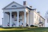
Flat Top Estate Flat Top Estate December 24, 2013 (#13000978 ) Blue Ridge Parkway , milepost 292.8 to 295.536°08′53″N 81°41′36″W / 36.147945°N 81.6932379°W / 36.147945; -81.6932379 (Flat Top Estate ) Blowing Rock
9
Former Randall Memorial Building Upload image March 14, 1991 (#91000263 ) Greenway Ct. 36°07′55″N 81°40′40″W / 36.131944°N 81.677778°W / 36.131944; -81.677778 (Former Randall Memorial Building ) Blowing Rock
10
Gragg House Upload image October 25, 1973 (#73001382 ) On U.S. 221 36°07′00″N 81°46′39″W / 36.116667°N 81.7775°W / 36.116667; -81.7775 (Gragg House ) Blowing Rock
11
Green Park Historic District Green Park Historic District August 19, 1994 (#94001020 ) Jct. of US 321 and Green Hill and Rock Rds. 36°07′17″N 81°39′38″W / 36.121389°N 81.660556°W / 36.121389; -81.660556 (Green Park Historic District ) Blowing Rock
12
Green Park Inn Green Park Inn June 3, 1982 (#82004637 ) U.S. 321 36°07′07″N 81°39′39″W / 36.118611°N 81.660833°W / 36.118611; -81.660833 (Green Park Inn ) Blowing Rock
13
Jones House Jones House March 25, 1987 (#87000483 ) 604 W. King St. 36°13′06″N 81°41′00″W / 36.218333°N 81.683333°W / 36.218333; -81.683333 (Jones House ) Boone
14
Mast Farm Mast Farm January 20, 1972 (#72001002 ) E of Valle Crucis off SR 1112 36°12′23″N 81°46′15″W / 36.206389°N 81.770833°W / 36.206389; -81.770833 (Mast Farm ) Valle Crucis
15
Mast General Store Mast General Store April 3, 1973 (#73001383 ) S of Valle Crucis on SR 1112 36°12′28″N 81°46′48″W / 36.207778°N 81.78°W / 36.207778; -81.78 (Mast General Store ) Valle Crucis
16
John Smith Miller House John Smith Miller House January 29, 2009 (#08001389 ) 561 Chestnut Grove Rd. 36°15′59″N 81°39′48″W / 36.266389°N 81.663472°W / 36.266389; -81.663472 (John Smith Miller House ) Boone
17
US Post Office-Boone US Post Office-Boone January 11, 1996 (#95001521 ) 679 W. King St. 36°13′11″N 81°41′10″W / 36.219722°N 81.686111°W / 36.219722; -81.686111 (US Post Office-Boone ) Boone
18
Valle Crucis Episcopal Mission Valle Crucis Episcopal Mission September 9, 1993 (#93000938 ) NC 194 N side, 1 miles SW of jct. with NC 1112 36°11′45″N 81°47′46″W / 36.195833°N 81.796111°W / 36.195833; -81.796111 (Valle Crucis Episcopal Mission ) Valle Crucis
19
Valle Crucis Historic District Valle Crucis Historic District February 2, 2005 (#04001600 ) Along NC 194 and NC 1112 36°12′33″N 81°46′43″W / 36.209247°N 81.778558°W / 36.209247; -81.778558 (Valle Crucis Historic District ) Valle Crucis
20
Vardell Family Cottages Historic District Vardell Family Cottages Historic District March 12, 2001 (#01000254 ) 222 Grandfather Ave, 137, 187, 209 Chestnut Circle 36°07′36″N 81°40′42″W / 36.126667°N 81.678333°W / 36.126667; -81.678333 (Vardell Family Cottages Historic District ) Blowing Rock
21
Ward Family House Ward Family House May 23, 1997 (#97000473 ) 8018 Rominger Rd. 36°14′50″N 81°49′21″W / 36.247222°N 81.8225°W / 36.247222; -81.8225 (Ward Family House ) Sugar Grove
22
Westglow Westglow August 13, 1979 (#79001762 ) W of Blowing Rock on U.S. 221 36°08′17″N 81°42′50″W / 36.138056°N 81.713889°W / 36.138056; -81.713889 (Westglow ) Blowing Rock
23
Wilson-Vines House Upload image December 22, 1997 (#97001562 ) 4300 Rush Branch Rd. 36°17′30″N 81°50′57″W / 36.291667°N 81.849167°W / 36.291667; -81.849167 (Wilson-Vines House ) Beaver Dam