

Port Lavaca (/ləˈvɑːkə/ ⓘ lə-VAH-kə) is a city in Calhoun County, located in the U.S. state of Texas. The population was 12,248 at the 2010 census[5] and 11,557 at the 2020 census. It is the county seat of Calhoun County[6] and part of the Port Lavaca, Texas micropolitan statistical area. Port Lavaca is 130 miles (210 km) southwest of Houston.
History
Port Lavaca was originally known as Lavaca. The town would quickly grow as a result of the Linnville Raid of 1840. This raid saw the town of Linville decimated by the Comanche tribe, and caused former residents of the town to settle in what is now Port Lavaca. Thomas McConnell would purchase a section of land from Isidro Benavides, and establish the town using this land[7]
Geography
Port Lavaca is located in northern Calhoun County on the west side of Lavaca Bay, an arm of Matagorda Bay. According to the United States Census Bureau, the city has a total area of 14.1 square miles (36.5 km2), of which 10.2 square miles (26.3 km2) is land and 3.9 square miles (10.2 km2), or 28.04%, is water.[5]
Climate
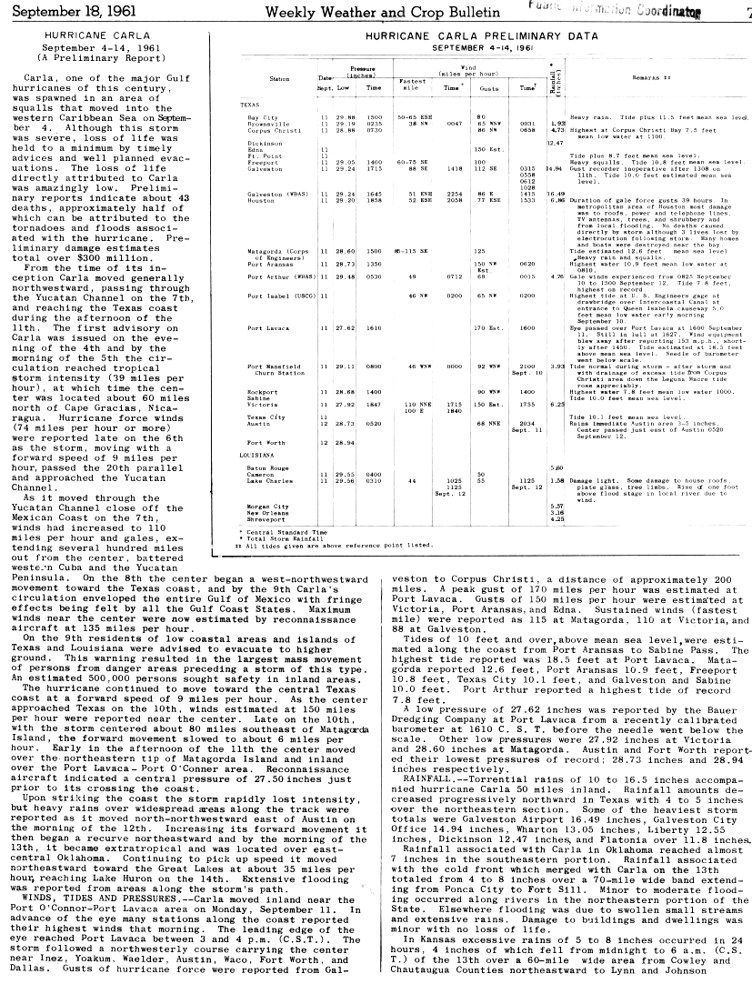
Port Lavaca holds the state record of the highest wind speed ever reached. During Hurricane Carla in September 1961, the winds were recorded to gust up to 170 miles per hour (270 km/h).[8]
In 2004, Port Lavaca, including the South Texas Area, recorded up to 12 inches (300 mm) of snowfall.
During Hurricane Harvey in August 2017, Port Lavaca was the location of the peak of the storm surge, which was measured at 6 ft (1.8 m).[9]
Port Lavaca also suffered damage in hurricanes in 1942 and 1945.[10]
Tropical Storm Beta also made landfall on Port Lavaca on late September 2020, causing flooding.
Demographics
| Census | Pop. | Note | %± |
|---|---|---|---|
| 1850 | 315 | — | |
| 1860 | 526 | 67.0% | |
| 1870 | 768 | 46.0% | |
| 1890 | 365 | — | |
| 1910 | 1,699 | — | |
| 1920 | 1,212 | −28.7% | |
| 1930 | 1,367 | 12.8% | |
| 1940 | 2,069 | 51.4% | |
| 1950 | 5,599 | 170.6% | |
| 1960 | 8,864 | 58.3% | |
| 1970 | 10,491 | 18.4% | |
| 1980 | 10,911 | 4.0% | |
| 1990 | 10,886 | −0.2% | |
| 2000 | 12,035 | 10.6% | |
| 2010 | 12,248 | 1.8% | |
| 2020 | 11,557 | −5.6% | |
| U.S. Decennial Census[11] | |||
2020 census
| Race | Number | Percentage |
|---|---|---|
| White (NH) | 2,957 | 25.59% |
| Black or African American (NH) | 303 | 2.62% |
| Native American or Alaska Native (NH) | 12 | 0.1% |
| Asian (NH) | 974 | 8.43% |
| Some Other Race (NH) | 20 | 0.17% |
| Mixed/Multi-Racial (NH) | 130 | 1.12% |
| Hispanic or Latino | 7,161 | 61.96% |
| Total | 11,557 |
As of the 2020 United States census, there were 11,557 people, 4,334 households, and 2,914 families residing in the city.
2000 Census data
As of the census[4] of 2000, there were 12,035 people, 4,189 households, and 3,133 families residing in the city. The population density was 1,229.9 inhabitants per square mile (474.9/km2). There were 4,791 housing units at an average density of 489.6 per square mile (189.0/km2). The racial makeup of the city was 71.95% White, 4.05% African American, 0.47% Native American, 3.96% Asian, 0.08% Pacific Islander, 16.92% from other races, and 2.58% from two or more races. Hispanic or Latino of any race were 50.11% of the population.
There were 4,189 households, out of which 39.0% had children under the age of 18 living with them, 56.5% were married couples living together, 13.7% had a female householder with no husband present, and 100.0% were non-families. 21.2% of all households were made up of individuals, and 8.5% had someone living alone who was 65 years of age or older. The average household size was 2.83 and the average family size was 3.31.
In the city, the population was 30.3% under the age of 18, 9.6% from 18 to 24, 28.7% from 25 to 44, 19.3% from 45 to 64, and 12.1% who were 65 years of age or older. The median age was 32 years. For every 100 females, there were 99.2 males. For every 100 females age 18 and over, there were 95.8 males. The median income for a household in the city was $33,626, and the median income for a family was $38,250. Males had a median income of $35,526 versus $18,427 for females. The per capita income for the city was $15,431. About 16.8% of families and 20.1% of the population were below the poverty line, including 25.0% of those under age 18 and 14.7% of those age 65 or over.
Economy

An important economic hub is the Port of Port Lavaca. The city is centrally located between several large manufacturing facilities including Alcoa, Formosa Plastics, and DuPont, where many Port Lavaca residents work. Fishing is an important part of the local economy, particularly shrimp and oysters. Tourism makes up a small portion of the Port Lavaca economy as well. "Winter Texans" from colder states and Canada stay in the city's many RV and camping parks between October and April.
Parks and recreation
Locally caught seafood can be found in some of the city's restaurants.
In 2006, two new fishing piers with lighting for night fishermen were constructed in Port Lavaca and one at the 6 Mile Park. This pier is located at the eastern end of Main Street in the vicinity of the Nautical Landings Marina. The second pier, Lighthouse Pier, is located on Hwy 35 at Lavaca Bay. The 6 Mile pier (and boat ramp) is located northwest on FM 1090 about 6 miles (10 km) from the intersection of Hwy 35 and FM 1090 (Virginia Street). Common game fish caught in the area include redfish, speckled trout, flounder, and drum.
Lighthouse Beach at the intersection of Hwy 35 and Lavaca Bay has covered picnic tables, swimming, and a birdwatching trail.
Education
Port Lavaca is served by the Calhoun County Independent School District. Port Lavaca is served by two Pre-Kindergarten through 5th grade and excellent special needs elementary programs: H.J.M Elementary School and Jackson/Roosevelt Elementary School. All residents are zoned to Travis Middle School (grades 6 through 8) and Calhoun High School (9 through 12). Hope High School is another high school, mainly for students with troubled pasts or behavioural issues. Our Lady of the Gulf Catholic school, Pre-K through grade 8, has also served the county since 1996.
Victoria College has an extension campus at the former Harrison Elementary School campus. Most of the courses offered there are through distance learning and "ITV" television learning from the VC main campus.
Infrastructure
Healthcare
Memorial Medical Center, which is located in the city of Port Lavaca is a small hospital that serves the city, and county as well.
Transportation
Calhoun County Airport, a general aviation airport, is located in unincorporated Calhoun County 5 miles (8 km) northwest of Port Lavaca.
U.S. 87 (Main Street) comes into Port Lavaca from the northwest as a four-lane divided highway, and then narrows down as it runs through Port Lavaca's historic downtown. Via US 87 it is 28 miles (45 km) to Victoria. Texas State Highway 35 is the other major road through Port Lavaca, running generally northeast–southwest through the city. To the northeast it crosses Lavaca Bay via the Port Lavaca Causeway and leads 29 miles (47 km) to Palacios, while to the southwest it leads 82 miles (132 km) to Corpus Christi.
Notable people
- Hope Dworaczyk (born 1984), Playboy magazine's 2010 Playmate of the Year[15]
- Nelva Gonzales Ramos (born 1965), former Texas State District Court judge, currently serving on the United States District Court for the Southern District of Texas[16]
- Steven Saylor (born 1956), writer of historical novels
- Brucene Smith, Miss World USA 1971, Miss USA International 1974, Miss International 1974
References
- ^ "2019 U.S. Gazetteer Files". United States Census Bureau. Retrieved August 7, 2020.
- ^ a b U.S. Geological Survey Geographic Names Information System: Port Lavaca, Texas
- ^ "Population and Housing Unit Estimates". United States Census Bureau. May 24, 2020. Retrieved May 27, 2020.
- ^ a b "U.S. Census website". United States Census Bureau. Retrieved January 31, 2008.
- ^ a b "Geographic Identifiers: 2010 Census Summary File 1 (G001): Port Lavaca city, Texas". U.S. Census Bureau, American Factfinder. Archived from the original on February 13, 2020. Retrieved July 8, 2015.
- ^ "Find a County". National Association of Counties. Retrieved June 7, 2011.
- ^ "Port Lavaca,TX". Texas State Historical Association. Retrieved February 20, 2024.
- ^ Cooperman, Arthur I.; Summer, Howard C. (September 18, 1961). "Hurricane Carla Preliminary Report". National Hurricane Center. United States Weather Bureau. Retrieved August 26, 2017.
- ^ "Hurricane Harvey". U-SURGE. Archived from the original on September 10, 2017. Retrieved September 10, 2017.
- ^ "Calhoun County Historical Commission - Historic Photos - Port Lavaca Hurricane Damage 1942". www.calhouncountyhc.org.
- ^ "Census of Population and Housing". Census.gov. Retrieved June 4, 2015.
- ^ "Explore Census Data". data.census.gov. Retrieved May 21, 2022.
- ^ https://www.census.gov/ [not specific enough to verify]
- ^ "About the Hispanic Population and its Origin". www.census.gov. Retrieved May 18, 2022.
- ^ Connelly, Richard. "Hope Dworaczyk, Playboy's First 3-D Centerfold, Is A Local Girl!!", Houston Press, May 11, 2010
- ^ Foley, Sara (January 26, 2011). "Nelva Gonzales Ramos nominated for federal judgeship". Corpus Christi Caller-Times. Retrieved April 14, 2011.
External links
- City of Port Lavaca official website
- Port Lavaca Chamber of Commerce
- Handbook of Texas Online article
Municipalities and communities of Calhoun County, Texas, United States | ||
|---|---|---|
| Cities | 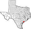 | |
| CDPs | ||
| Other communities | ||
| Ghost town | ||
| International | |
|---|---|
| National | |
| Geographic | |