

Vaiʻava Strait (Samoan: Vāinuʻu o Vaiʻava) is a narrow strait in Vatia, American Samoa which separates the 420-foot-high (130 m) Pola Island (Cock's Comb) from Polauta Ridge on adjacent Tutuila Island. The strait is a good example of cliffs formed by the erosional forces of waves on volcanic rock. The lands surrounding the strait are held communally. A 250-acre (100 ha) area surrounding the strait was designated a U.S. National Natural Landmark in 1972.[1] Pola-Uta is connected to the village of Vatia on Tutuila Island. Pola Tai is a 400-foot (120 m) cliff that is an important nesting area for the fuaʻō (brown booby) and tavaʻe (white tailored tropic bird). Hunting of brown boobies, known as the Aʻega o le Pola, was a tradition carried out by Vatians in the past. Pola Tai includes Matalia Point, Cockscomb Point and Polauta Ridge.[2][3]
It is located on the north coast of Tutuila Island, on the northwestern side of the village of Vatia. It is a designated 250 acres (100 ha) National Natural Landmark, but also a part of the National Park of American Samoa. Erosion by the sea has sculpted deep cliffs and sea arches in the rocks of a huge volcanic plug (Pola Island). The 420 feet (130 m) cliffs and rock top are important nesting and resting areas for several seabird species.[4]
Gallery
-
 Vaiʻava Strait, 1907
 -

-
 Eastern point of Vatia Bay
 -
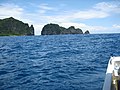
 Polauta Ridge and Pola Island


See also
References
- ^ "Vaiʻava Strait". nps.gov. National Park Service.
- ^ Harris, Ann G. and Esther Tuttle (2004). Geology of National Parks: Volume 2. Kendall Hunt. Page 609. ISBN 9780787299705.
- ^ Faiʻivae, Alex Godinet (2018). Ole Manuō o Tala Tuʻu Ma Fisaga o Tala Ave. Amerika Samoa Humanities Council. Page 66. ISBN 9781546229070.
- ^ Goldin, Meryl Rose (2002). Field Guide to the Samoan Archipelago: Fish, Wildlife, and Protected Areas. Bess Press. Page 284. ISBN 9781573061117.
External links
- Vaiʻava Strait National Park Service