

Size of this preview: 800 × 572 pixels. Other resolutions: 320 × 229 pixels | 640 × 458 pixels | 1,024 × 732 pixels.
Original file (1,024 × 732 pixels, file size: 138 KB, MIME type: image/jpeg)
Summary
|
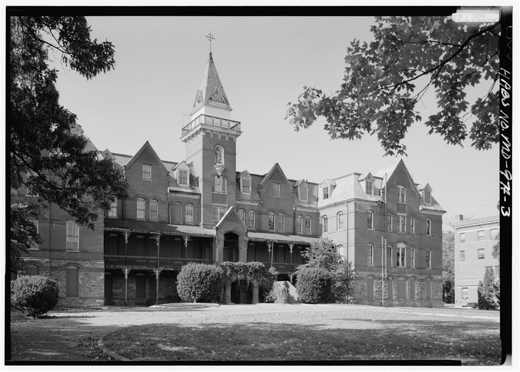
This is an image of a place or building that is listed on the National Register of Historic Places in the United States of America. Its reference number is 75002081. |
| Description |
English: View of the southeast face of the Ammendale Normal Institute in Beltsville, Maryland, looking north.
|
|||||||||||||||||||||||||
| Date | Taken on 9 October 1990 | |||||||||||||||||||||||||
| Source | HABS MD,17-BELTV,3-3, Library of Congress Prints & Photographs Division | |||||||||||||||||||||||||
| Author |
|
|||||||||||||||||||||||||
| Object location | | View this and other nearby images on: OpenStreetMap |
|---|
Licensing

|
This file comes from the Historic American Buildings Survey (HABS), Historic American Engineering Record (HAER) or Historic American Landscapes Survey (HALS). These are programs of the National Park Service established for the purpose of documenting historic places. Records consist of measured drawings, archival photographs, and written reports.
This tag does not indicate the copyright status of the attached work. A normal copyright tag is still required. See Commons:Licensing. |
| This image or media file contains material based on a work of a National Park Service employee, created as part of that person's official duties. As a work of the U.S. federal government, such work is in the public domain in the United States. See the NPS website and NPS copyright policy for more information. |
Wikipedia upload log
A Wikipedia description page is/was here. All following user names refer to en.wikipedia.
- 2008-10-27 23:56 Pubdog 1024×732× (140967 bytes) {{Information |Description=PERSPECTIVE VIEW OF SOUTHEAST (FRONT) LOOKING NORTH HABS MD,17-BELTV,3-3 |Source=Library of Congress Prints & Photographs Division |Date= Oct 27, 2008 |Author=Historic American Buildings Survey / Historic American Engineering Re
File history
Click on a date/time to view the file as it appeared at that time.
| Date/Time | Thumbnail | Dimensions | User | Comment | |
|---|---|---|---|---|---|
| current | 21:55, 18 January 2009 | | 1,024 × 732 (138 KB) | File Upload Bot (Magnus Manske) | {{BotMoveToCommons|en.wikipedia}} {{Information |Description={{en|PERSPECTIVE VIEW OF SOUTHEAST (FRONT) LOOKING NORTH HABS MD,17-BELTV,3-3}} |Source=Transferred from [http://en.wikipedia.org en.wikipedia]; transferred to Commons by [[User:NuclearWarfare] |
File usage
The following pages on the English Wikipedia use this file (pages on other projects are not listed):
Global file usage
The following other wikis use this file:
- Usage on www.wikidata.org