

No higher resolution available.
Georef_Example_Patuxent.png (369 × 149 pixels, file size: 13 KB, MIME type: image/png)
Summary
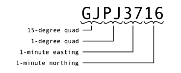
An example Georef co-ordinate, showing how it is broken down into its constituent parts. This is the co-ordinate of Patuxent Naval Air Station.
Created using Inkscape SVG on Linux by S/V Moonrise.
Licensing
File history
Click on a date/time to view the file as it appeared at that time.
| Date/Time | Thumbnail | Dimensions | User | Comment | |
|---|---|---|---|---|---|
| current | 12:44, 19 December 2005 | 369 × 149 (13 KB) | Johantheghost (talk | contribs) | An example Georef co-ordinate, showing how it is broken down into its constituent parts. This is the co-ordinate of Patuxent Naval Air Station. Created using Inkscape SVG on Linux by [http://moonrise.ws S/V Moonrise]. |
You cannot overwrite this file.
File usage
The following pages on the English Wikipedia use this file (pages on other projects are not listed):