

The George P. Coleman Memorial Bridge (known locally as simply the Coleman Bridge) is a double swing bridge that spans the York River between Yorktown and Gloucester Point, in the United States state of Virginia. It connects the Peninsula and Middle Peninsula regions of Tidewater, Virginia. The bridge is the only public crossing of the York River, though State Route 33 crosses both of its tributaries (the Mattaponi and Pamunkey Rivers) just upriver of their confluence at West Point.
History
Originally built in 1952, it was reconstructed and widened in 1995 through an unusual process which greatly reduced the time the important commuter artery was out-of-service from conventional methods. The current 3,750-foot (1,140 m)-long double-swing-span bridge carries United States Route 17, a four-lane arterial highway. The movable span is needed to allow ship access to several military installations that are upstream of the bridge, most notably, the United States Navy's Naval Weapons Station Yorktown. The roadways are almost 90 feet (27 m) above the river at the highest point of the bridge. The bridge is the largest double-swing-span bridge in the United States, and second largest in the world.[1][2]
The toll bridge was named for George P. Coleman, who from 1913 to 1922 was the head of the Virginia Department of Highways and Transportation, predecessor to the Virginia Department of Transportation (VDOT). The bridge has been one of the sites of a special program to establish and encourage nesting locations for the peregrine falcon population of Virginia.
Toll rates
The George P. Coleman Memorial Bridge is a toll facility. Tolls are only collected northbound, and are used to pay for the expansion of the bridge to four lanes. Toll Collection Rates are as follows:[3]
- Bicycles 0¢
- EZ-Pass (transponder required) 85¢
- Motorcycles 85¢
- Two-axle vehicles $2
- Three-axle vehicles $3
- Four- or more-axle vehicles $4
Bicycles taking advantage of the free crossing must use the established bicycle lane located to the right of the far right travel lane.[4]
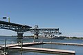
Photos
-
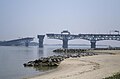 Bridge swung open as seen from Yorktown side, Summer 2011
 -
 One of the two swing spans while fully turned (open for river traffic)
 -
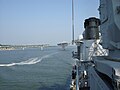
 Opened bridge as seen from aboard a Navy ship
 -
 Bridge swinging closed as seen from down York River
 -
 Entering Bridge from Yorktown side
 -
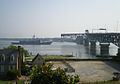 USS Elrod (FFG-55) about to pass through the George P. Coleman Memorial Bridge on the York River, Summer 2011
 -
 USS Arleigh Burke traveling under the bridge.


See also
 Transport portal
 Engineering portal
 Virginia portal
- List of bridges documented by the Historic American Engineering Record in Virginia
References
- ^ "BUILDING BIG: Databank: George P. Coleman Bridge". pbs.org.
- ^ "George P. Coleman Bridge". roadstothefuture.com.
- ^ "Hampton Roads Tunnels and Bridges". Virginia Department of Transportation. Retrieved 10 June 2019.
- ^ "VDOT :: Coleman Bridge". ezpassva.com.
External links
- PBS.org description of the bridge
- George P. Coleman Bridge (1952) at Structurae
- George P. Coleman Bridge (1995) at Structurae
- VDOT website for Peregrine Falcon news
- Roads to the Future: George P. Coleman Bridge
- Historic American Engineering Record (HAER) No. VA-57, "George P. Coleman Memorial Bridge, Spanning York River at United States Route 17, Yorktown, York County, VA"
| Water crossings |
| ||||||||||
|---|---|---|---|---|---|---|---|---|---|---|---|
| Aviation, rail and transit services |
| ||||||||||
| Planned projects | |||||||||||
| International | |
|---|---|
| Geographic | |