


Size of this preview: 800 × 564 pixels. Other resolutions: 320 × 226 pixels | 640 × 451 pixels | 964 × 680 pixels.
Original file (964 × 680 pixels, file size: 132 KB, MIME type: image/jpeg)
|
This is an image of a place or building that is listed on the National Register of Historic Places in the United States of America. Its reference number is 73002259. |
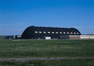
| Description |
English: Exterior view of the Goodyear Airdock.
Français : Le Goodyear Airdock vu de l'extérieur. |
| Date | 26 January 2009 (original upload date) |
| Source | Transferred from en.wikipedia to Commons by Stepshep using CommonsHelper. |
| Author | The original uploader was IanManka at English Wikipedia. |
| Object location | | View this and other nearby images on: OpenStreetMap |
|---|
Licensing

|
This file comes from the Historic American Buildings Survey (HABS), Historic American Engineering Record (HAER) or Historic American Landscapes Survey (HALS). These are programs of the National Park Service established for the purpose of documenting historic places. Records consist of measured drawings, archival photographs, and written reports.
This tag does not indicate the copyright status of the attached work. A normal copyright tag is still required. See Commons:Licensing. |
| This image or media file contains material based on a work of a National Park Service employee, created as part of that person's official duties. As a work of the U.S. federal government, such work is in the public domain in the United States. See the NPS website and NPS copyright policy for more information. |
Original upload log
The original description page was here. All following user names refer to en.wikipedia.
- 2009-01-26 21:50 Stepshep 964×680× (135275 bytes) trim up
- 2006-07-18 21:20 IanManka 1024×735× (156112 bytes) {{HABS| ImageURL=http://memory.loc.gov/cgi-bin/displayPhoto.pl?path=/pnp/habshaer/oh/oh0400/oh0481/color&topImages=570982cr.jpg&topLinks=570982cv.jpg,570982cu.tif&title=31.%20%20GENERAL%20VIEW%20OF%20AIRDOCK%20LOOKING%20SOUTH%20%3cbr%3eHAER%20OHIO,77-AKRO
File history
Click on a date/time to view the file as it appeared at that time.
| Date/Time | Thumbnail | Dimensions | User | Comment | |
|---|---|---|---|---|---|
| current | 02:36, 11 March 2009 | | 964 × 680 (132 KB) | File Upload Bot (Magnus Manske) | {{BotMoveToCommons|en.wikipedia|year={{subst:CURRENTYEAR}}|month={{subst:CURRENTMONTHNAME}}|day={{subst:CURRENTDAY}}}} {{Information |Description={{en|''no original description''}} |Source=Transferred from [http://en.wikipedia.org en.wikipedia]; transfer |
File usage
The following pages on the English Wikipedia use this file (pages on other projects are not listed):
Global file usage
The following other wikis use this file:
- Usage on de.wikipedia.org
- Usage on es.wikipedia.org
- Usage on fr.wikipedia.org
- Usage on pt.wikipedia.org
- Usage on vi.wikipedia.org
- Usage on www.wikidata.org