


Size of this PNG preview of this SVG file: 600 × 600 pixels. Other resolutions: 240 × 240 pixels | 480 × 480 pixels | 768 × 768 pixels | 1,024 × 1,024 pixels | 2,048 × 2,048 pixels | 1,063 × 1,063 pixels.
Original file (SVG file, nominally 1,063 × 1,063 pixels, file size: 187 KB)
Summary
| Description |
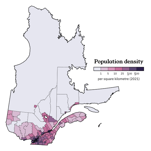
English: Population density of Quebec according to the 2021 Canadian census. Geography: Census divisions + selected northern cities separated (Chibougamau, Val D'Or, Baie-Comeau, Port-Cartier, Sept-Îles) + selected northern unincorporated territories separated. These boundaries have been chosen to match administrative reality while accurately showing which parts of the North are settled more densely. Some Indian reserves abstained from the census in 2021 and are not counted here. Projection: EPSG:6624. |
| Date | |
| Source | Own work |
| Author | Awmcphee |
Licensing
I, the copyright holder of this work, hereby publish it under the following license:
This file is licensed under the Creative Commons Attribution-Share Alike 4.0 International license.
- You are free:
- to share – to copy, distribute and transmit the work
- to remix – to adapt the work
- Under the following conditions:
- attribution – You must give appropriate credit, provide a link to the license, and indicate if changes were made. You may do so in any reasonable manner, but not in any way that suggests the licensor endorses you or your use.
- share alike – If you remix, transform, or build upon the material, you must distribute your contributions under the same or compatible license as the original.
File history
Click on a date/time to view the file as it appeared at that time.
| Date/Time | Thumbnail | Dimensions | User | Comment | |
|---|---|---|---|---|---|
| current | 07:36, 1 April 2024 | | 1,063 × 1,063 (187 KB) | Awmcphee | Updated geography - Saguenay now more accurate |
| 07:27, 1 April 2024 |  | 1,063 × 1,063 (179 KB) | Awmcphee | Uploaded own work with UploadWizard |
File usage
The following pages on the English Wikipedia use this file (pages on other projects are not listed):