


Size of this preview: 458 × 600 pixels. Other resolutions: 183 × 240 pixels | 366 × 480 pixels | 586 × 768 pixels | 782 × 1,024 pixels | 1,390 × 1,820 pixels.
Original file (1,390 × 1,820 pixels, file size: 814 KB, MIME type: image/jpeg)
Summary
| Description |
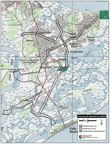
English: Map of battlefield core and study areas.
The ABPP significantly revised the 1993 Study Area and included the routes taken by Confederate reinforcements marching from Charleston and Fort Johnson to help repulse the Federal assault on Tower Battery/Fort Lamar. The width of existing Federal approaches was reduced to highlight the roads used by US troops moving through the otherwise impassible, swampy terrain of James Island. Also included is the approach route of US naval forces travelling up Folly River Creek. The expanded Core Area includes the US naval bombardment from Folly River Creek and the Confederate counter attack north of Fort Lamar. |
| Date | |
| Source | National Park Service |
| Author | American Battlefield Protection Program |
Licensing
| This image or media file contains material based on a work of a National Park Service employee, created as part of that person's official duties. As a work of the U.S. federal government, such work is in the public domain in the United States. See the NPS website and NPS copyright policy for more information. |
File history
Click on a date/time to view the file as it appeared at that time.
| Date/Time | Thumbnail | Dimensions | User | Comment | |
|---|---|---|---|---|---|
| current | 15:40, 24 October 2016 | | 1,390 × 1,820 (814 KB) | SDriskell | User created page with UploadWizard |
File usage
The following pages on the English Wikipedia use this file (pages on other projects are not listed):