


Size of this preview: 800 × 533 pixels. Other resolutions: 320 × 213 pixels | 640 × 427 pixels | 1,024 × 683 pixels | 1,280 × 853 pixels | 2,560 × 1,707 pixels | 5,512 × 3,675 pixels.
Original file (5,512 × 3,675 pixels, file size: 15.01 MB, MIME type: image/jpeg)
Summary
| Description |
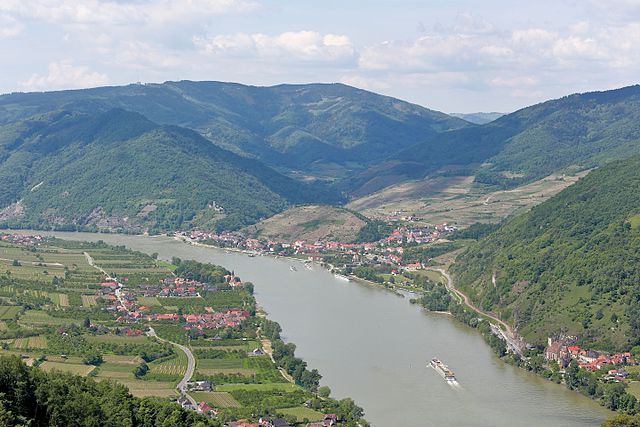
Deutsch: Die Wachau im Bereich Spitz an der Donau bzw. Blick von einem Vorgipfel des 671 Meter hohen Seekopfes, Richtung Westen. Links von vorne nach hinten die Ortschaften Bach-, Mitter-, Hof- und Oberarnsdorf, die alle zur Marktgemeinde Rossatz-Arnsdorf gehören. Rechts im Vordergrund die Ortschaft St. Michael (Marktgemeinde Weißenkirchen in der Wachau) mit der Wehrkirche St. Michael bzw. "Mutterkirche der Wachau" und dahinter Spitz an der Donau. |
| Date | |
| Source | Own work |
| Author | C.Stadler/Bwag |
| Permission (Reusing this file) |
Deutsch: Hallo, du darfst mein Foto kostenlos nutzen, aber nenne mich bitte als Fotograf, beispielsweise „Foto: C.Stadler/Bwag“ oder © C.Stadler/Bwag; CC-BY-SA-4.0. Auf mehr Angaben bestehe ich nicht - im Gegensatz zu manch anderen, die die Vorgaben der unten angeführten Lizenzierung auf Punkt und Beistrich einfordern. English: Feel free to use my photos, but please mention me as the author like © C.Stadler/Bwag or © C.Stadler/Bwag; CC-BY-SA-4.0 (that's good enough) and if you want send me a message: bwag@gmx.net. |
| Other versions |
|
.JPG)
| Camera location | | View this and other nearby images on: OpenStreetMap |
|---|
.JPG¶ms=048.373225_N_0015.462165_E_globe:Earth_type:camera_alt:517.6_source:exif_&language=en)
Licensing
I, the copyright holder of this work, hereby publish it under the following license:
This file is licensed under the Creative Commons Attribution-Share Alike 4.0 International license.
- You are free:
- to share – to copy, distribute and transmit the work
- to remix – to adapt the work
- Under the following conditions:
- attribution – You must give appropriate credit, provide a link to the license, and indicate if changes were made. You may do so in any reasonable manner, but not in any way that suggests the licensor endorses you or your use.
- share alike – If you remix, transform, or build upon the material, you must distribute your contributions under the same or compatible license as the original.
| Annotations | This image is annotated: View the annotations at Commons |
.JPG)
File history
Click on a date/time to view the file as it appeared at that time.
| Date/Time | Thumbnail | Dimensions | User | Comment | |
|---|---|---|---|---|---|
| current | 18:23, 25 May 2016 | | 5,512 × 3,675 (15.01 MB) | Bwag | {{Information |Description= {{de|1=Die Wachau im Bereich Spitz an der Donau bzw. Blick vom Sonnstein, ein Vorgipfel des 671 Meter hohen Seekopfes, Richtung Westen.</br>Links von vorn... |
File usage
The following pages on the English Wikipedia use this file (pages on other projects are not listed):
Global file usage
The following other wikis use this file:
- Usage on cs.wikipedia.org
- Usage on fi.wikipedia.org
- Usage on li.wikipedia.org
- Usage on nl.wikipedia.org
- Usage on os.wikipedia.org
.JPG)