

Size of this preview: 800 × 370 pixels. Other resolutions: 320 × 148 pixels | 640 × 296 pixels | 1,357 × 628 pixels.
Original file (1,357 × 628 pixels, file size: 25 KB, MIME type: image/png)

|
File:Iberian Union empires.svg is a vector version of this file. It should be used in place of this PNG file when not inferior.
File:Iberian Union Empires.png → File:Iberian Union empires.svg
For more information, see Help:SVG. |
 |
| Description |
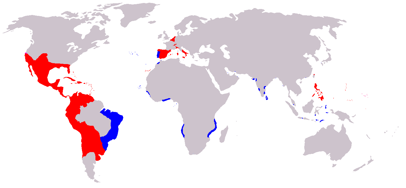
A map of the Spanish and Portuguese Empires in the period of their personal union (1581-1640). Blue: Portuguese Empire; Red: Spanish Empire; |
||
| Source | English Wikipedia, original description is/was here. | ||
| Author | en:User:Câmara | ||
| Permission (Reusing this file) |
|
File history
Click on a date/time to view the file as it appeared at that time.
| Date/Time | Thumbnail | Dimensions | User | Comment | |
|---|---|---|---|---|---|
| current | 07:00, 20 November 2019 | | 1,357 × 628 (25 KB) | Geographyinitiative | Added Spanish Formosa |
| 15:05, 4 January 2009 |  | 1,357 × 628 (22 KB) | The Red Hat of Pat Ferrick | Trim size of Portuguese colonies, remove "claims" areas. | |
| 16:32, 12 July 2007 |  | 1,357 × 628 (38 KB) | Gveret Tered | {{Information |Description==A map of the Spanish and Portuguese Empires in the period of their personal union (1581-1640). == Licensing ==. |Source=[http://en.wikipedia.org English Wikipedia], original description is/was [[:en:Image:Iberian Union Empires. |
File usage
The following pages on the English Wikipedia use this file (pages on other projects are not listed):
Global file usage
The following other wikis use this file:
- Usage on ar.wikipedia.org
- Usage on ast.wikipedia.org
- Usage on azb.wikipedia.org
- Usage on be.wikipedia.org
- Usage on ca.wikipedia.org
- Usage on cs.wikipedia.org
- Usage on da.wikipedia.org
- Usage on de.wikipedia.org
- Usage on es.wikipedia.org
- Usage on fa.wikipedia.org
- Usage on fr.wikipedia.org
- Usage on gl.wikipedia.org
- Usage on he.wikipedia.org
- Usage on hu.wikipedia.org
- Usage on io.wikipedia.org
- Usage on it.wikipedia.org
- Usage on ja.wikipedia.org
View more global usage of this file.