Colonel William A. Phillips

Page contents not supported in other languages.

Original file(3,034 × 1,742 pixels, file size: 976 KB, MIME type: image/jpeg)

Summary

Description
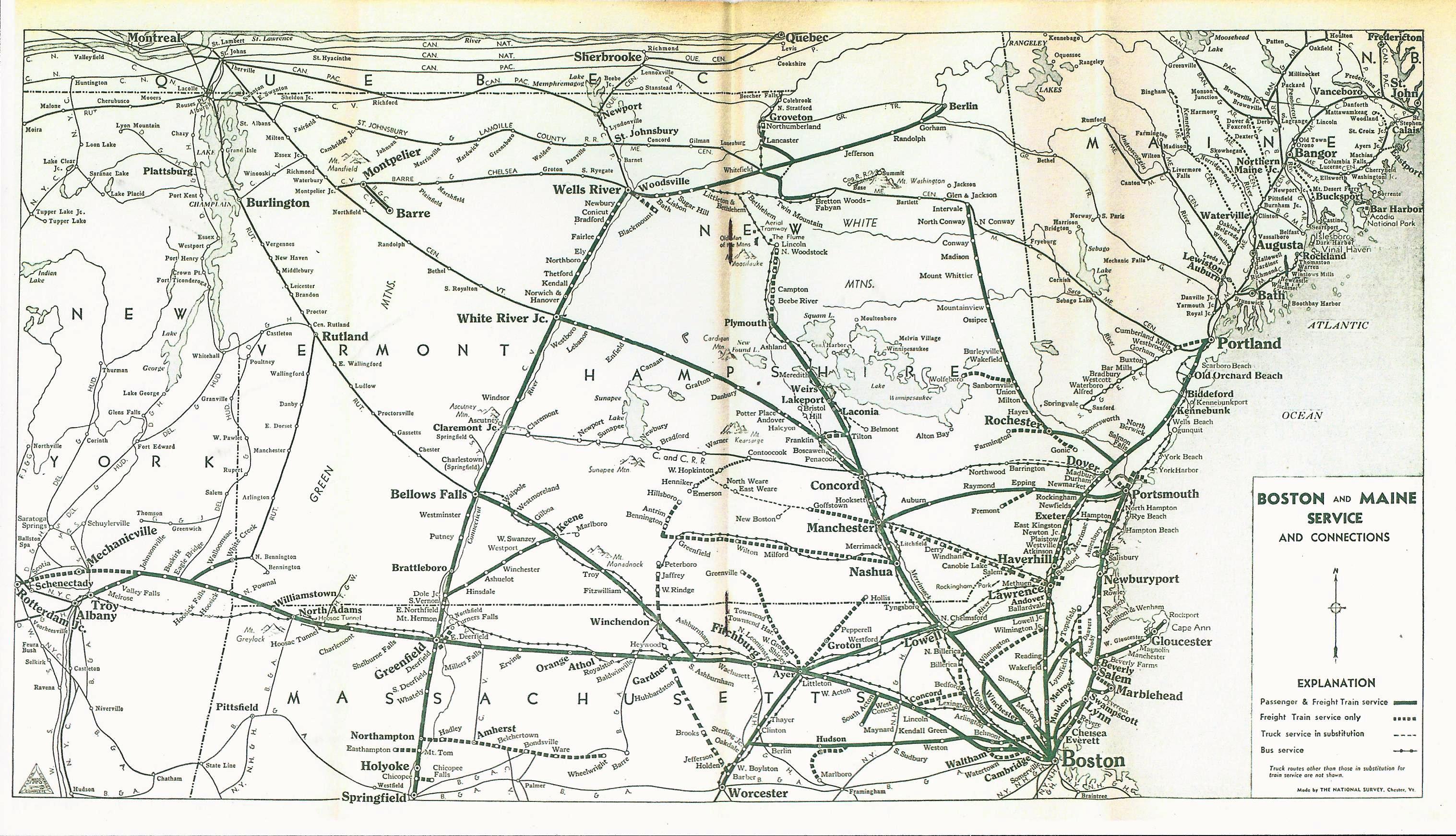
English: System map of the Boston and Maine Railroad from a 1956 timetable
Date
Source Scanned version from Flickr
Author National Survey Company (for the Boston and Maine Railroad)
Permission
(Reusing this file)
This image is in the public domain because it is a mere mechanical scan or photocopy of a public domain original, or – from the available evidence – is so similar to such a scan or photocopy that no copyright protection can be expected to arise. The original itself is in the public domain for the following reason:
Public domain
This work is in the public domain because it was published in the United States between 1929 and 1963, and although there may or may not have been a copyright notice, the copyright was not renewed. For further explanation, see Commons:Hirtle chart and the copyright renewal logs. Note that it may still be copyrighted in jurisdictions that do not apply the rule of the shorter term for US works (depending on the date of the author's death), such as Canada (70 years p.m.a.), Mainland China (50 years p.m.a., not Hong Kong or Macao), Germany (70 years p.m.a.), Mexico (100 years p.m.a.), Switzerland (70 years p.m.a.), and other countries with individual treaties.

العربية  Deutsch  English  español  français  galego  italiano  日本語  한국어  македонски  português  português do Brasil  русский  sicilianu  slovenščina  українська  简体中文  繁體中文 

Flag of the United States

This tag is designed for use where there may be a need to assert that any enhancements (eg brightness, contrast, colour-matching, sharpening) are in themselves insufficiently creative to generate a new copyright. It can be used where it is unknown whether any enhancements have been made, as well as when the enhancements are clear but insufficient. For known raw unenhanced scans you can use an appropriate {{PD-old}} tag instead. For usage, see Commons:When to use the PD-scan tag.


Note: This tag applies to scans and photocopies only. For photographs of public domain originals taken from afar, {{PD-Art}} may be applicable. See Commons:When to use the PD-Art tag.

Captions

Add a one-line explanation of what this file represents

Items portrayed in this file

depicts

inception

29 April 1956

MIME type

image/jpeg

checksum

a7a783499067a45f6c2b290dba99b840f157937f

determination method: SHA-1

data size

999,441 byte

height

1,742 pixel

width

3,034 pixel

File history

Click on a date/time to view the file as it appeared at that time.

Date/TimeThumbnailDimensionsUserComment
current22:37, 24 February 2018Thumbnail for version as of 22:37, 24 February 20183,034 × 1,742 (976 KB)Pi.1415926535{{Information |description ={{en|1=System map of the Boston and Maine Railroad from a 1956 timetable}} |source =Scanned version from [https://www.flickr.com/photos/photolibrarian/12593086123/in/album-72157639066642733/ Flickr] |author =National Survey Company (for the Boston and Maine Railroad) |date =1956-04-29 |permission ={{PD-scan|PD-US-not renewed}} }} Category:1956 in rail transport in the United States Category:1956 maps 1956 1956 1956 1956
The following pages on the English Wikipedia use this file (pages on other projects are not listed):