

No higher resolution available.
Bougainville_campaign_1945.jpg (203 × 550 pixels, file size: 118 KB, MIME type: image/jpeg)
Summary
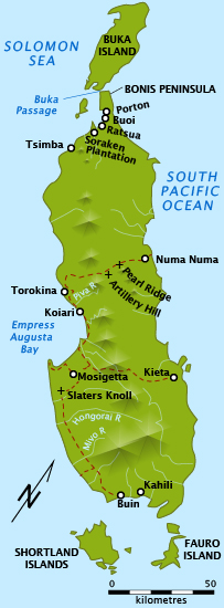
| Description | Shows key locations relating to Australian battles in Bougainville campaign, World War II, 1945. |
| Date | |
| Source |
Own work
|
| Author | Chris Rees User:SpoolWhippets |
| Permission (Reusing this file) |
This file is licensed under the Creative Commons Attribution-Share Alike 3.0 Unported license.
|
File history
Click on a date/time to view the file as it appeared at that time.
| Date/Time | Thumbnail | Dimensions | User | Comment | |
|---|---|---|---|---|---|
| current | 00:20, 17 February 2018 | 203 × 550 (118 KB) | SpoolWhippets | Brought back rivers which went missing in last version. Place name "Navoi" reverted to "Koiari". | |
| 10:27, 11 February 2018 | 203 × 550 (118 KB) | SpoolWhippets | Added Kieta and Mosigetta | ||
| 23:35, 2 April 2010 | 203 × 550 (107 KB) | SpoolWhippets | corrected positions of Artillery Hill and Pearl Ridge, as per map in Long, ch5, p111 | ||
| 01:00, 2 April 2010 | 220 × 574 (106 KB) | SpoolWhippets | Added Koiari and Piva River | ||
| 12:16, 29 March 2010 | 220 × 574 (105 KB) | SpoolWhippets | Added details and reverted to 220 wide | ||
| 13:03, 16 March 2010 | 440 × 1,148 (276 KB) | SpoolWhippets | Added Fauro island, doubled size | ||
| 12:25, 15 March 2010 | 220 × 574 (100 KB) | SpoolWhippets | move bonis pen. text | ||
| 12:23, 15 March 2010 | 220 × 574 (100 KB) | SpoolWhippets | Fix bad crop | ||
| 12:18, 15 March 2010 | 202 × 550 (100 KB) | SpoolWhippets | {{Information |Description={{en|1=Shows key locations relating to Australian battles in Bougainville campaign, World War II, 1945.}} |Source={{own}} |Author=SpoolWhippets |Date=2010-03-15 |Permission= |other_versions= }} [[Category |
File usage
The following pages on the English Wikipedia use this file (pages on other projects are not listed):
Global file usage
The following other wikis use this file:
- Usage on azb.wikipedia.org
- Usage on de.wikipedia.org
- Usage on es.wikipedia.org
- Usage on he.wikipedia.org
- Usage on hu.wikipedia.org
- Usage on id.wikipedia.org
- Usage on it.wikipedia.org
- Usage on ja.wikipedia.org
- Usage on pl.wikipedia.org
- Usage on ru.wikipedia.org
- Usage on sv.wikipedia.org
- Usage on www.wikidata.org
- Usage on zh.wikipedia.org