


Size of this preview: 800 × 600 pixels. Other resolutions: 320 × 240 pixels | 640 × 480 pixels | 1,024 × 768 pixels | 1,280 × 960 pixels | 2,560 × 1,920 pixels | 2,848 × 2,136 pixels.
Original file (2,848 × 2,136 pixels, file size: 3.16 MB, MIME type: image/jpeg)
|
This is an image of a place or building that is listed on the National Register of Historic Places in the United States of America. Its reference number is 85003401. |
Summary
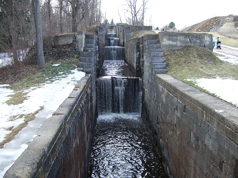
| Description | Fort Edward, NY, USA. "The Flight" (today called "The Combine") is a series of five locks on the old Glens Falls Feeder Canal which raised/lowered canal boats a total of 55 vertical feet (16.76 m). Built in 1845, this series of locks replaced the original timber locks of the 1820s and '30s. These locks are 15 feet wide (4.57m) and 100 feet long (30.48m); these dimensions controlled the size of canal boats in the Champlain Canal system so long as these locks were in use. Water from this branch canal (pulled from above the falls in Glens Falls) fed into the highest point of the Champlain Canal, providing a source to replenish water lost both back into the Hudson River to the south and into Lake Champlain to the north. |
| Date | |
| Source | Own work |
| Author | Planmeister |
| Object location | | View this and other nearby images on: OpenStreetMap |
|---|
Licensing
| I, the copyright holder of this work, release this work into the public domain. This applies worldwide. In some countries this may not be legally possible; if so: I grant anyone the right to use this work for any purpose, without any conditions, unless such conditions are required by law. |
File history
Click on a date/time to view the file as it appeared at that time.
| Date/Time | Thumbnail | Dimensions | User | Comment | |
|---|---|---|---|---|---|
| current | 16:17, 7 May 2008 | | 2,848 × 2,136 (3.16 MB) | Planmeister | {{Information |Description= |Source=self-made |Date=5 April 2008 |Author= Planmeister |Permission= |other_versions= }} |
File usage
The following pages on the English Wikipedia use this file (pages on other projects are not listed):
Global file usage
The following other wikis use this file:
- Usage on arz.wikipedia.org
- Usage on ceb.wikipedia.org
- Usage on de.wikipedia.org
- Usage on es.wikipedia.org
- Usage on fr.wikipedia.org
- Usage on www.wikidata.org