

No higher resolution available.
Ohiodistrict2.jpg (282 × 286 pixels, file size: 32 KB, MIME type: image/jpeg)
| Description |
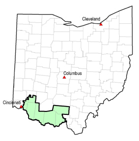
State of Ohio, showing counties and 2nd Congressional District. File made by Antandrus using ESRI ArcView and public domain data from the US Census. |
||
| Date | Unknown date | ||
| Source | en:Image:Ohiodistrict2.jpg | ||
| Author | Antandrus | ||
| Permission (Reusing this file) |
|
File history
Click on a date/time to view the file as it appeared at that time.
| Date/Time | Thumbnail | Dimensions | User | Comment | |
|---|---|---|---|---|---|
| current | 06:15, 13 October 2006 | | 282 × 286 (32 KB) | Vopvop | {{Information |Description=State of Ohio, showing counties and 2nd Congressional District. File made by Antandrus using ESRI ArcView and public domain data from the US Census. |Source=en:Image:Ohiodistrict2.jpg |Date=Unknown | |
File usage
The following pages on the English Wikipedia use this file (pages on other projects are not listed):