


Size of this preview: 800 × 535 pixels. Other resolutions: 320 × 214 pixels | 640 × 428 pixels | 1,024 × 685 pixels | 1,280 × 857 pixels | 2,560 × 1,713 pixels | 5,070 × 3,393 pixels.
Original file (5,070 × 3,393 pixels, file size: 20.37 MB, MIME type: image/jpeg)
Summary
| Description |
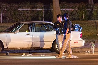
Minnesota Bureau of Criminal Apprehension (BCA) investigators process the scene of where a St. Anthony Police officer shot and killed 32-year-old Philando Castile in a car near Larpenteur Avenue and Fry Street in Falcon Heights, Minnesota, on July 6, 2016. Photo: Tony Webster / tony@tonywebster.com
|
| Date | |
| Source | Philando Castile Car - BCA Investigators, Falcon Heights |
| Author | Tony Webster from Minneapolis, Minnesota |
| Camera location | | View this and other nearby images on: OpenStreetMap |
|---|
.jpg¶ms=044.991886_N_-093.170981_E_globe:Earth_type:camera_source:Flickr_&language=en)
Licensing
This file is licensed under the Creative Commons Attribution-Share Alike 2.0 Generic license.
- You are free:
- to share – to copy, distribute and transmit the work
- to remix – to adapt the work
- Under the following conditions:
- attribution – You must give appropriate credit, provide a link to the license, and indicate if changes were made. You may do so in any reasonable manner, but not in any way that suggests the licensor endorses you or your use.
- share alike – If you remix, transform, or build upon the material, you must distribute your contributions under the same or compatible license as the original.
| This image was originally posted to Flickr by Tony Webster at https://flickr.com/photos/87296837@N00/28110858346. It was reviewed on 7 July 2016 by FlickreviewR and was confirmed to be licensed under the terms of the cc-by-sa-2.0. |
File history
Click on a date/time to view the file as it appeared at that time.
| Date/Time | Thumbnail | Dimensions | User | Comment | |
|---|---|---|---|---|---|
| current | 22:24, 7 July 2016 | | 5,070 × 3,393 (20.37 MB) | SunOfErat | Transferred from Flickr via Flickr2Commons |
File usage
The following pages on the English Wikipedia use this file (pages on other projects are not listed):
.jpg)