


Original file (1,216 × 2,000 pixels, file size: 1.17 MB, MIME type: image/jpeg)
Summary
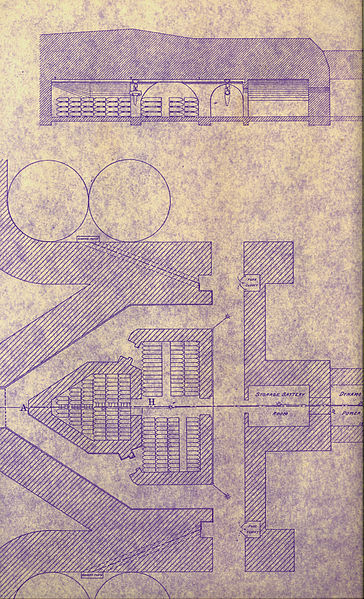
This image is a scan of a portion of an 1896 plan for the Ft. Banks mortar batteries, drawn by the U.S. (Army) Engineers.
For orientation, west is to the right of the drawing, with south at the top. The two circles at top are the northernmost two firing positions of Btty Lincoln, Pit A. The two southernmost firing positions of Pit B are at the very bottom. For scale, the larger shell room at the center of the drawing is 30 ft. long on its longest dimension (the one at a right angle to the line A-H).
The plan shows how the space would accommodate shells of three different lengths: 3 ft., 3 ft. 8 in., and 5 ft., stacked four courses high. The section at top shows a view along the axis A-H and indicates how shell hoists/trolleys would be used to lift and transport the shells along the corridors, where they were placed on shell carts and wheeled out to the floors of the mortar pits.
This 1896 plan shows the original, as-built layout for the mortar pits, with the individual mortars placed quite close to each other. It also shows the plan for the diagonal raceways running from the walls of the mortar pits back to the "firing niches" inside the magazine corridors, where electrical firing switches for the mortars were to be located. It is not clear if this arrangement for firing the mortars was actually put into practice.
The space at right marked "Storage Battery Room" would have held lead-acid batteries, charged by the "Dynamo" (generator) in the adjacent room, and used to power the telephones and fire the mortars. These spaces were later replaced with steps and an access way from the deeper, old magazines to the higher center and flank magazines of Btty Lincoln, which at that time had their floors at ground level.
Licensing
File history
Click on a date/time to view the file as it appeared at that time.
| Date/Time | Thumbnail | Dimensions | User | Comment | |
|---|---|---|---|---|---|
| current | 19:11, 17 September 2010 | | 1,216 × 2,000 (1.17 MB) | Pgrig (talk | contribs) | This image is a scan of a portion of an 1896 plan for the Ft. Banks mortar batteries, drawn by the U.S. (Army) Engineers. For orientation, east is to the right of the drawing. The two circles at top are the northernmost two firing positions of Btty Linco |
You cannot overwrite this file.