


Size of this PNG preview of this SVG file: 783 × 599 pixels. Other resolutions: 314 × 240 pixels | 627 × 480 pixels | 1,004 × 768 pixels | 1,280 × 980 pixels | 2,560 × 1,959 pixels | 946 × 724 pixels.
Original file (SVG file, nominally 946 × 724 pixels, file size: 1,017 KB)
Summary
| Description |
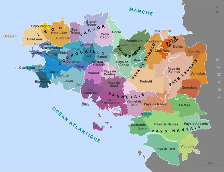
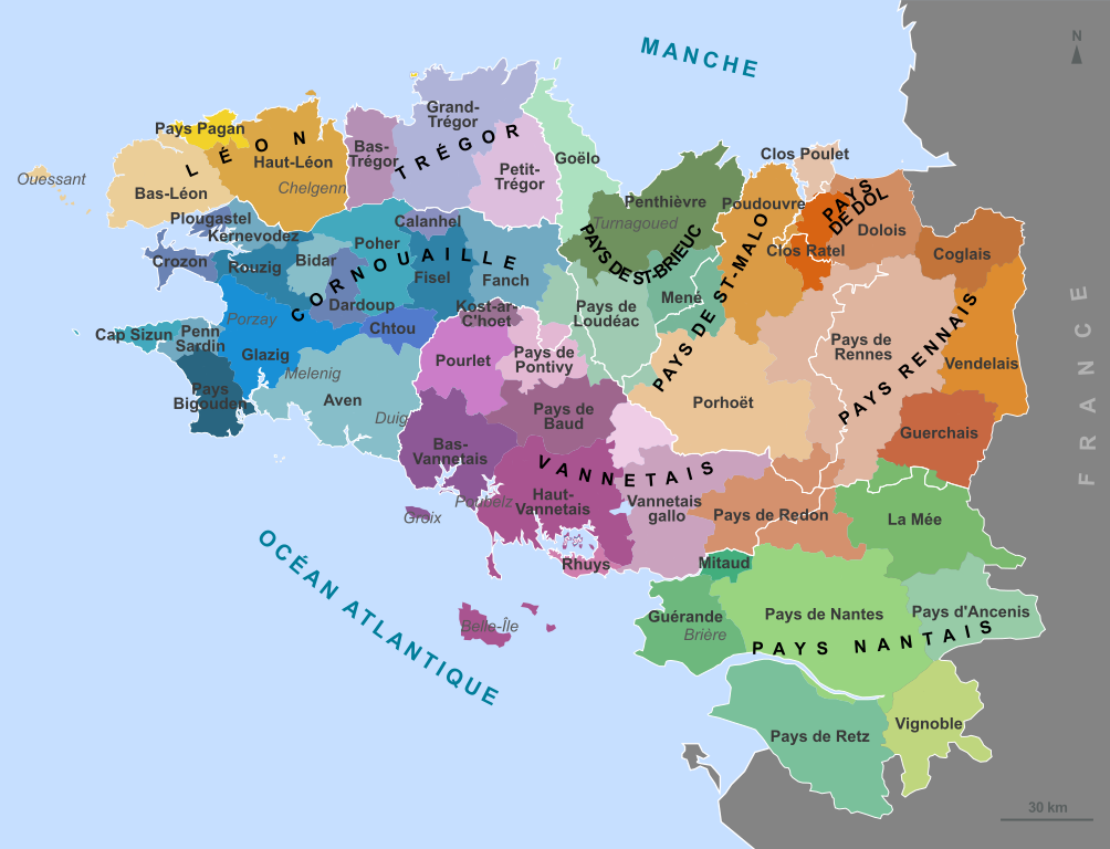
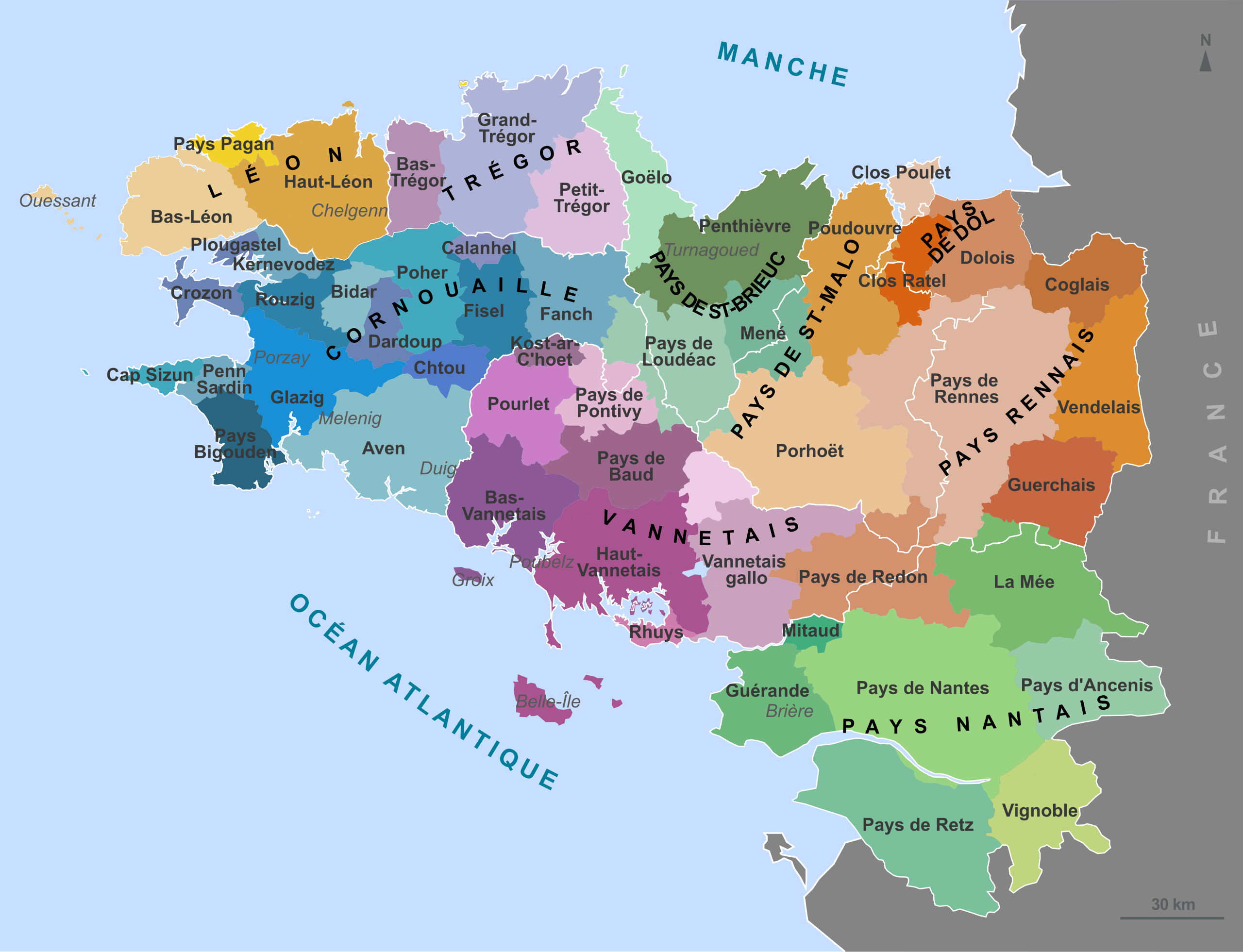
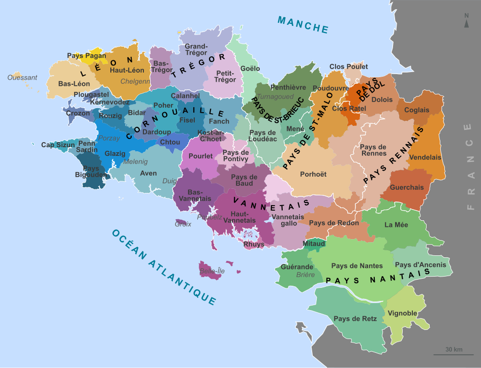
English: Map of the traditional regions of Brittany (France) Français : Carte des pays traditionnels bretons. Brezhoneg: Kartenn broioù hengounel Breizh (e galleg) |
||
| Date | (UTC) | ||
| Source | |||
| Author |
|
||
| Permission (Reusing this file) |
I, the copyright holder of this work, hereby publish it under the following licenses: This file is licensed under the Creative Commons Attribution-Share Alike 3.0 Unported, 2.5 Generic, 2.0 Generic and 1.0 Generic license.
You may select the license of your choice. |
||
| Other versions |
Derivative works of this file: Bretagne historic location map.svg
|


This vector image was created with Inkscape .

|
This SVG file contains embedded text that can be translated into your language, using any capable SVG editor, text editor or the SVG Translate tool. For more information see: About translating SVG files. |
Original upload log
This image is a derivative work of the following images:
- File:France_Pays_bretons_map.jpg licensed with Cc-by-sa-3.0,2.5,2.0,1.0, GFDL
- 2010-03-31T12:59:09Z Pethrus 1500x1189 (835023 Bytes) {{Information |Description={{en|Map of the traditionnal regions of Bretagne (France)}}{{fr|Carte des pays traditionnels bretons}} |Source=[http://www.geobreizh.com www.geobreizh.com], Mikael Bodlore-Penlaez |Date=2010-03-30 |
Uploaded with derivativeFX
File history
Click on a date/time to view the file as it appeared at that time.
| Date/Time | Thumbnail | Dimensions | User | Comment | |
|---|---|---|---|---|---|
| current | 08:10, 23 April 2010 | | 946 × 724 (1,017 KB) | Pethrus | Border fixed. |
| 13:09, 22 April 2010 |  | 946 × 724 (1,017 KB) | Pethrus | Name fix. | |
| 12:51, 22 April 2010 |  | 946 × 724 (1,017 KB) | Pethrus | {{Information |Description={{en|Map of the traditionnal regions of Brittany (France)}}{{fr|Carte des pays traditionnels bretons.}} |Source=*File:France_Pays_bretons_map.jpg {{inkscape}} |Date=2010-04-22 12:50 (UTC) |Author=*[[:File:France_Pays_breto |
File usage
The following pages on the English Wikipedia use this file (pages on other projects are not listed):
Global file usage
The following other wikis use this file:
- Usage on an.wikipedia.org
- Usage on ca.wikipedia.org
- Usage on de.wikipedia.org
- Usage on el.wikipedia.org
- Usage on eo.wikipedia.org
- Usage on es.wikipedia.org
- Usage on fr.wikipedia.org
- Duché de Bretagne
- Drapeau de la Bretagne
- Pays Bigouden
- Porhoët
- Pays de Retz
- Pays de la Mée
- Saint-Nicolas-du-Pélem
- Haute-Bretagne
- Penthièvre
- Goëlo
- Pays de Bretagne
- Kost ar c'hoad
- Poudouvre
- Pays Pourlet
- Pays Glazik
- Gilles de Rais
- Coglais
- Wikipédia:Atelier graphique/Cartes/Archives/avril 2010
- Presqu'île guérandaise
- Pays Fañch
- Mitau
- Pays du Vignoble nantais
- Pays de Guérande
- Vendelais
- Guerchais
- Portail:Histoire de Bretagne
- Portail:Histoire de Bretagne/Présentation
- Pays Chelgen
- Kost ar c'hoad (pays)
- Pays Fisel
- Pays Rouzig
- Farine de blé noir de Bretagne
- Usage on fr.wikivoyage.org
- Usage on fr.wiktionary.org
View more global usage of this file.