


Size of this preview: 509 × 599 pixels. Other resolutions: 204 × 240 pixels | 600 × 706 pixels.
Original file (600 × 706 pixels, file size: 256 KB, MIME type: image/jpeg)
Summary
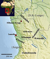
| Description | Map of Mbundu history related regions. |
| Date | |
| Source | Added text on the File:Africa topography map with borders.png and File:Africa satellite orthographic.jpg |
| Author | Kohirgabr, based on work by Bamse |
Licensing
This file is licensed under the Creative Commons Attribution-Share Alike 3.0 Unported license.
- You are free:
- to share – to copy, distribute and transmit the work
- to remix – to adapt the work
- Under the following conditions:
- attribution – You must give appropriate credit, provide a link to the license, and indicate if changes were made. You may do so in any reasonable manner, but not in any way that suggests the licensor endorses you or your use.
- share alike – If you remix, transform, or build upon the material, you must distribute your contributions under the same or compatible license as the original.
File history
Click on a date/time to view the file as it appeared at that time.
| Date/Time | Thumbnail | Dimensions | User | Comment | |
|---|---|---|---|---|---|
| current | 10:10, 9 September 2009 | | 600 × 706 (256 KB) | Kohirgabr | == Summary == {{Information |Description=Map of Mbundu history related regions |Source=Added text on the images http://commons.wikimedia.org/wiki/Image%3AAfrica_topography_map_with_borders.png and http://commons.wikimedia.org/wiki/Image:Africa_satellite_ |
File usage
The following pages on the English Wikipedia use this file (pages on other projects are not listed):
Global file usage
The following other wikis use this file:
- Usage on be.wikipedia.org
- Usage on ca.wikipedia.org
- Usage on fr.wikipedia.org
- Usage on ja.wikipedia.org
- Usage on kg.wikipedia.org
- Usage on lt.wikipedia.org
- Usage on nl.wikipedia.org
- Usage on sh.wikipedia.org