


Size of this preview: 619 × 599 pixels. Other resolutions: 248 × 240 pixels | 496 × 480 pixels | 1,000 × 968 pixels.
Original file (1,000 × 968 pixels, file size: 211 KB, MIME type: image/png)
Summary
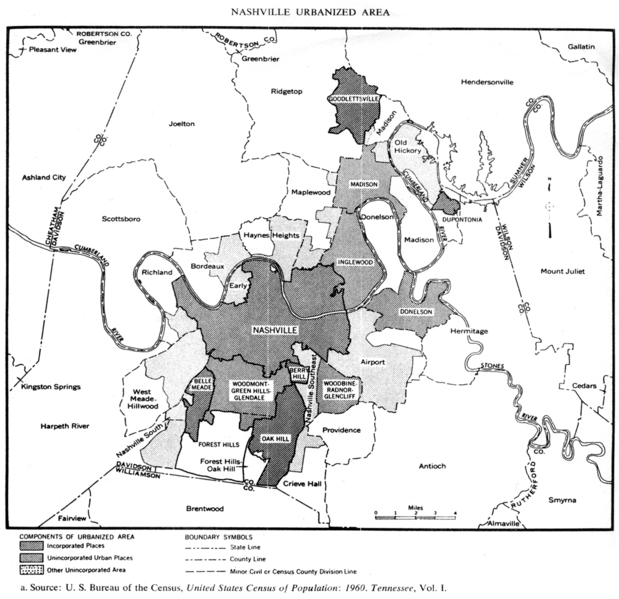
| Description | Map of the Nashville area in 1960 from the U.S. Census Bureau. |
| Date | |
| Source | United States Census of Population: 1960, Tennessee |
| Author | U.S. Census Bureau |
Licensing
This work is in the public domain in the United States because it is a work prepared by an officer or employee of the United States Government as part of that person’s official duties under the terms of Title 17, Chapter 1, Section 105 of the US Code.
Note: This only applies to original works of the Federal Government and not to the work of any individual U.S. state, territory, commonwealth, county, municipality, or any other subdivision. This template also does not apply to postage stamp designs published by the United States Postal Service since 1978. (See § 313.6(C)(1) of Compendium of U.S. Copyright Office Practices). It also does not apply to certain US coins; see The US Mint Terms of Use.
|
 | |
| This file has been identified as being free of known restrictions under copyright law, including all related and neighboring rights. | ||
File history
Click on a date/time to view the file as it appeared at that time.
| Date/Time | Thumbnail | Dimensions | User | Comment | |
|---|---|---|---|---|---|
| current | 23:18, 5 June 2009 | | 1,000 × 968 (211 KB) | Kaldari | {{Information |Description=Map of the Nashville area in 1960 from the U.S. Census Bureau. |Source=On file at the Nashville Public Library |Date=1961 |Author=U.S. Census Bureau |Permission= |other_versions= }} [[Category:Nashville, |
File usage
The following pages on the English Wikipedia use this file (pages on other projects are not listed):