

Fletcher Peak is an 11,410-foot-elevation (3,478 meter) mountain summit located in Yosemite National Park, in Mariposa County, California, United States. It is situated south of Tuolumne Meadows in the Cathedral Range which is a sub-range of the Sierra Nevada mountain range. The mountain rises one mile (1.6 km) south of Tuolumne Pass, 1.3 miles (2.1 km) northeast of proximate parent Vogelsang Peak and 1.8 miles (2.9 km) northwest of line parent Parsons Peak.[3] Topographic relief is significant as the summit rises 1,250 feet (380 meters) above Fletcher Lake in 0.38 miles (0.61 km). Precipitation runoff from this landform drains south to the Merced River via Fletcher Creek.
Etymology
Fletcher Creek and Fletcher Lake were named in 1895 by Lieutenant Nathaniel Fish McClure to honor Arthur G. Fletcher, deputy fish commissioner of California's State Board of Fish Commissioners, who directed the stocking of fish in the streams and lakes of Yosemite National Park.[6] The peak was named in association, and this geographical feature's toponym was officially adopted in 1932 by the U.S. Board on Geographic Names.[4] The landform had been named "Baker Peak" prior to the Fletcher name, for a Mr. Baker who was a cook at nearby Boothe Lake Camp.[4][7]
Climate
According to the Köppen climate classification system, Fletcher Peak is located in an alpine climate zone.[8] Most weather fronts originate in the Pacific Ocean, and travel east toward the Sierra Nevada mountains. As fronts approach, they are forced upward by the peaks (orographic lift), causing them to drop their moisture in the form of rain or snowfall onto the range.
See also
Gallery
-
 North aspects of Fletcher Peak (left) and Vogelsang Peak (right)
 -
-
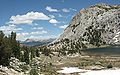
 Southwest aspect of Fletcher Peak (right) above Vogelsang Lake
 -
 Northeast aspect seen from Evelyn Lake
 -
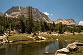
 Southwest aspect of Fletcher Peak (right) with Vogelsang Lake
 -
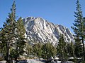
 Fletcher Peak upper left
 -
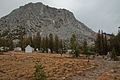 West aspect from Vogelsang High Sierra Camp


References
- ^ R. J. Secor, The High Sierra Peaks, Passes, Trails, 2009, Third Edition, Mountaineers Books, ISBN 9781594857386, p. 319
- ^ "Fletcher Peak, California". Peakbagger.com. Retrieved 2022-06-18.
- ^ a b c d "Fletcher Peak - 11,410' CA". listsofjohn.com. Retrieved 2022-06-18.
- ^ a b c "Fletcher Peak". Geographic Names Information System. United States Geological Survey, United States Department of the Interior. Retrieved 2022-06-18.
- ^ Edward S. Robbins and Alfred W. Baxter, Jr., A Climber's Guide to the High Sierra (1954)
- ^ Francis P. Farquhar, Place Names of the High Sierra (1926)
- ^ Decisions of the United States Geographic Board, June 30, 1932, p. 9.
- ^ "Climate of the Sierra Nevada". Encyclopædia Britannica.
External links
- Weather forecast: Fletcher Peak