

Ivins Mountain is a remote 7,019-foot (2,139 m) Navajo Sandstone summit located in Zion National Park, in Washington County of southwest Utah, United States.[2]
Description
Ivins Mountain is situated 7.5 mi (12.1 km) north of Springdale, Utah. Its nearest higher neighbor is Inclined Temple, one half mile to the south, and South Guardian Angel is set approximately three miles to the west. Its name was officially adopted in 1935 by the U.S. Board on Geographic Names.[2] This geographical feature is named after Anthony W. Ivins (1852–1934), a pioneer of southern Utah, and apostle of the Church of Jesus Christ of Latter-day Saints.[2] The town of Ivins, Utah, also bears his name. The first ascent of Ivins Mountain via its west face was made in April 2015 by Dan Stih and Matthew Mower.[3] Precipitation runoff from this mountain drains into North Creek, a tributary of the Virgin River.
Climate
Spring and fall are the most favorable seasons to visit Ivins Mountain. According to the Köppen climate classification system, it is located in a Cold semi-arid climate zone, which is defined by the coldest month having an average mean temperature below 32 °F (0 °C), and at least 50% of the total annual precipitation being received during the spring and summer. This desert climate receives less than 10 inches (250 millimeters) of annual rainfall, and snowfall is generally light during the winter.[4]
Gallery
-
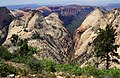 Ivins Mountain (left), seen from West Rim Trail
 -
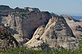 Ivins Mountain (right), Inclined Temple (left)
 -
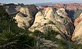 Inclined Temple (left) and Ivins Mountain seen from West Rim Trail
 -
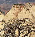
 Ivins Mountain centered, South Guardian Angel (upper right)
 -
 East aspect
 -
 Anthony W. Ivins in 1921


See also
References
- ^ a b c d e "Ivins Mountain - 7,019' UT". listsofjohn.com. Retrieved 2020-09-09.
- ^ a b c d U.S. Geological Survey Geographic Names Information System: Ivins Mountain
- ^ "AAC Publications - Ivins Mountain, West Face". publications.americanalpineclub.org. Retrieved 2020-09-10.
- ^ "Zion National Park, Utah, USA - Monthly weather forecast and Climate data". Weather Atlas. Archived from the original on 2019-01-27. Retrieved 2020-08-31.
External links
- Zion National Park National Park Service
- Ivins Mountain: Weather forecast