

Ramshorn Peak is an 11,635-foot-elevation (3,546-meter) mountain summit located in Fremont County of Wyoming, United States.[3]
Description
The peak is situated approximately 16 miles east of the Continental Divide in the Absaroka Range. It is set in the Washakie Wilderness, on land managed by Shoshone National Forest. Topographic relief is significant as both the east and west aspects rise 2,000 feet (610 meters) in one-half mile. The nearest town is Dubois, Wyoming, 16 miles to the south-southeast, and the peak is a conspicuous landmark seen from U.S. Route 26 / U.S. 287. The mountain's name has been officially adopted by the United States Board on Geographic Names, and was in use in 1914 when published in an USGS bulletin.[3][4] The first ascent of the summit was made July 13, 1960, by H. & Mrs. Kellogg.[5]
Climate
According to the Köppen climate classification system, Ramshorn Peak is located in an alpine subarctic climate zone with cold, snowy winters, and cool to warm summers.[6] Due to its altitude, it receives precipitation all year, as snow in winter, and as thunderstorms in summer. Precipitation runoff from the mountain drains into tributaries of the Wind River.
See also
Gallery
-
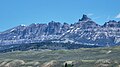 Ramshorn Peak from SSW at Union Pass, zoomed in
 -
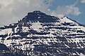 Southeast aspect
 -
 Dubois with Ramshorn Peak to the north


References
- ^ a b "Ramshorn Peak, Wyoming". Peakbagger.com. Retrieved 2021-08-01.
- ^ a b c "Ramshorn Peak - 11,635' WY". listsofjohn.com. Retrieved 2021-08-01.
- ^ a b c "Ramshorn Peak". Geographic Names Information System. United States Geological Survey, United States Department of the Interior. Retrieved 2021-08-01.
- ^ USGS, 1914, US Government Printing Office, page 139.
- ^ Orrin H. Bonney, Lorraine G. Bonney, 1965, Guide to the Wyoming Mountains and Wilderness Areas, Sage Books, page 418.
- ^ Peel, M. C.; Finlayson, B. L.; McMahon, T. A. (2007). "Updated world map of the Köppen−Geiger climate classification". Hydrol. Earth Syst. Sci. 11. ISSN 1027-5606.
External links
- Weather forecast: Ramshorn Peak
- Climbing Ramshorn Peak: Selectpeaks.com